Filter: Categories of Wisconsin Historical Images
Filter: Subject of Service stations
Filter: Subject of human settlements
Filter: Categories of Wisconsin Historical Images
Filter: Subject of Service stations
Filter: Subject of human settlements

| Date: | 09 02 1955 |
|---|---|
| Description: | Night view of Mobil gas station at the corner of Highway 51 and East Washington including station, gas pumps, one automobile, and a "Mobilgas" sign on a po... |

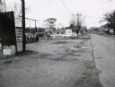
| Date: | 12 29 1947 |
|---|---|
| Description: | C & P Drive-In market sign, 3830 Atwood Avenue, featuring Borden's Ice Cream and Waterloo Sausage Co. Also shows John Olson's Standard Service Station sign... |
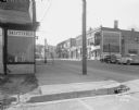
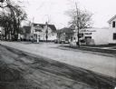
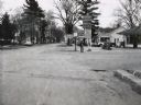
| Date: | 11 23 1947 |
|---|---|
| Description: | East Wilson Street at corner of South Hancock intersection looking toward West Wilson Street-King Street intersection taken to document site of Reynolds Bu... |
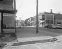
| Date: | 11 23 1947 |
|---|---|
| Description: | East Wilson Street at corner of South Hancock intersection looking toward West Wilson Street-King Street intersection taken to document site of Reynolds Bu... |

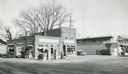
| Date: | 1929 |
|---|---|
| Description: | Exterior view of Droster's Grocery store and filling station. The business was located on the corner of 1438 North Sherman Avenue and Logan Street and was ... |

| Date: | 1928 |
|---|---|
| Description: | Droster Store at the corner of Burke and Felland Road. It is currently the Burke Station Tavern. |
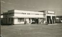
| Date: | |
|---|---|
| Description: | Exterior view of the Pan-Am Cafe, attached to a gas station. |
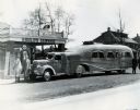
| Date: | 1938 |
|---|---|
| Description: | International "Jungle Yacht" parked at "Gould's" service station on the way from an International Harvester factory to New York City. Explorer Attilio Gatt... |

| Date: | 01 16 1927 |
|---|---|
| Description: | View across State Street toward cars lining up at Pennco filling (gas) station at the corner of State and Gorham Streets to get free crankcase draining and... |
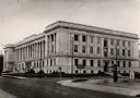
| Date: | 1925 |
|---|---|
| Description: | The third of Kenosha County courthouses, located on the corner of Sheridan and 56th Street. The courthouse cost $1,000,000 to construct. In the foreground ... |
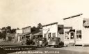
| Date: | |
|---|---|
| Description: | View from street towards cars parked at an angle in front of storefronts. Signs on the buildings read: "The Gift Shoppe," "Groceries and Meats," "Flambeau ... |
| Date: | 1967 |
|---|---|
| Description: | A Standard Oil service station located on Oxford Street (State Highway 21&73) in Wautoma, Wisconsin. This photograph relates to the neighborhood view in 3... |
| Date: | 1967 |
|---|---|
| Description: | Deep Rock gasoline service station located at the intersection of Scott Street and Oxford Street (STH 21&73) in Wautoma, Wisconsin. |
| Date: | 1967 |
|---|---|
| Description: | Zephyr gasoline station on STH 21&73 in Wautoma, Wisconsin. |

| Date: | 1967 |
|---|---|
| Description: | Sinclair station located on STH 21, 22 & 73 in Wautoma, Wisconsin. |
| Date: | 1957 |
|---|---|
| Description: | Skelly service station, restaurant, and motel located along STH 12 in Mauston, Wisconsin. |
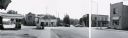
| Date: | |
|---|---|
| Description: | Intersection in Fremont, Wisconsin, showing two service stations. The panorama was created by the Department of Transportation by taping together three pr... |

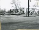
| Date: | |
|---|---|
| Description: | Triangle Super Service gas station, 635 South Spooner Street at the corner of Monroe Street. It was demolished so that Randall Bank could be built on the s... |
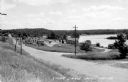
| Date: | 1948 |
|---|---|
| Description: | View from left side of road towards several buildings and a lake on the right. Down the road automobiles are parked outside of a building with a sign that ... |
If you didn't find the material you searched for, our Library Reference Staff can help.
Call our reference desk at 608-264-6535 or email us at: