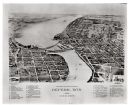
| Date: | 1890 |
|---|---|
| Description: | Bird's-eye view of Sheboygan on an advertisement for Kempf's Magical Salve, distributed by E.J. Kempf, "Legitimate Bill Poster and Distributor." |

| Date: | 1893 |
|---|---|
| Description: | Bird’s-eye view of Depere looking North. Includes illustrations and an index to points of interest. |

| Date: | 1856 |
|---|---|
| Description: | This map shows the city as planned by the General Colonization Society, including streets, land parcels, two subdivisions of out-lots with graveyard, schoo... |

| Date: | 1891 |
|---|---|
| Description: | Page 13 of a Sanborn map of Stevens Point. |
If you didn't find the material you searched for, our Library Reference Staff can help.
Call our reference desk at 608-264-6535 or email us at: