 Filter: Categories of Wisconsin Historical Images
Filter: Subject of Selling
Filter: Subject of ponds
Filter: Categories of Wisconsin Historical Images
Filter: Subject of Selling
Filter: Subject of ponds
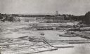
| Date: | 1866 |
|---|---|
| Description: | Elevated view taken from the extreme end of Clark's Saw and Planing Mill. An old flour mill can be seen behind the bridge, and to the extreme right are thr... |

| Date: | 1789 |
|---|---|
| Description: | Map of New York City showing ward boundaries, ferries, streets, roads, swamps, ponds, and rivers. The properties of Lispinard, Byards, Jones, Rutgers, and ... |
If you didn't find the material you searched for, our Library Reference Staff can help.
Call our reference desk at 608-264-6535 or email us at:
