 Filter: Categories of Wisconsin Historical Images
Filter: Subject of Seashore
Filter: Subject of cities and towns
Filter: Categories of Wisconsin Historical Images
Filter: Subject of Seashore
Filter: Subject of cities and towns
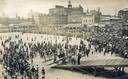
| Date: | 1910 |
|---|---|
| Description: | Elevated view of crowd gathered on the beach at Atlantic City to watch a Curtiss airplane being pushed on an inclined ramp leading to the boardwalk. |
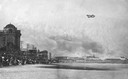
| Date: | 07 1910 |
|---|---|
| Description: | A Wright airplane on the beach. Walter Brookins, who piloted the plane to a new altitude record, is thought to be the man in the hat near the center. |
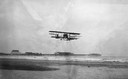
| Date: | 07 1910 |
|---|---|
| Description: | Walter Brookins, a boyhood friend of the Wright Brothers, flying a Wright airplane over the ocean at Atlantic City. Brookins set numerous records for altit... |
| Date: | 07 1912 |
|---|---|
| Description: | Glenn Curtiss flying over the ocean. The pontoons under each wing illustrate the beginnings of his development of amphibious aircraft. The famous Steel Pie... |

| Date: | 1915 |
|---|---|
| Description: | View along boardwalk, with people sitting, and other people walking. Buildings are along the left, and on the right is a lifeguard tower that looks down o... |
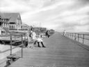
| Date: | |
|---|---|
| Description: | View down wide boardwalk, with a man and a young girl sitting on a boardwalk bench on the left. Several other people look out at the ocean from the railing... |
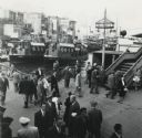
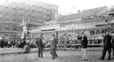
| Date: | 1951 |
|---|---|
| Description: | Elevated view of pedestrians at the harbor at Istanbul, Turkey. |
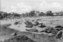
| Date: | 1920 |
|---|---|
| Description: | View along rocky shoreline towards adults and children on the seashore, nde wading in the water. In the distance are cottages and other buildings, possibly... |
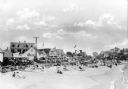
| Date: | 1910 |
|---|---|
| Description: | View along beach toward sunbathers sitting and walking along the seashore. A line of automobiles are parked alongside the beach, separated from the sand by... |
| Date: | 1920 |
|---|---|
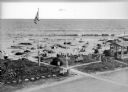
| Description: | Elevated view of the Dipsy Baths outbuilding and surrounding beach. Umbrellas are set up in the sand where people sunbathe or wade in the water, and an Ame... |
| Date: | 1910 |
|---|---|
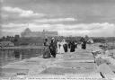
| Description: | A group of adults, mostly women, walk along the Rockland Breakwater. The Samoset Resort is in the background on the shoreline. Caption reads: "The Samoset ... |
| Date: | |
|---|---|
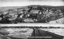
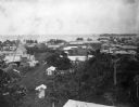
| Description: | Two views of the city. The upper photograph features an elevated view looking west. The lower photograph by O.D. Goetze is taken from a railroad bridge l... |
| Date: | |
|---|---|
| Description: | View of First Wharf from the Bering Sea. A railroad bridge leads to the shoreline. |
| Date: | |
|---|---|
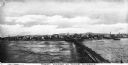
| Description: | A view of the city at high tide. Text on the photograph reads, "Nome. For Five Months in the Year Nome Can Be Reached by Steamship. Its Distance From Sea... |

| Date: | 1918 |
|---|---|
| Description: | Elevated view of Troitsky prospect in Archangel [Archangelsk], Russia, looking south, showing homes, churches, state buildings, as well as the statue of Pe... |
| Date: | 1902 |
|---|---|
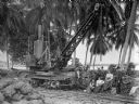
| Description: | Two men and three women posing next to a crane on a railroad track along the coast of Costa Rica. Coconut palms are behind them along the Caribbean Sea. Th... |
| Date: | 1902 |
|---|---|
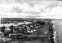
| Description: | Elevated view of the city of Port Limon, Costa Rica with the Caribbean Sea in the background. Trees grow amongst the many commercial and residential buildi... |
| Date: | 1917 |
|---|---|
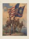
| Description: | Poster featuring an illustration of four Marine corpsmen on a beach, with one Marine holding an American flag and another Marine a Marines flag. The other ... |

| Date: | 1925 |
|---|---|
| Description: | Map of northern Africa with the border between Algeria and Tunisia drawn in red. Caption reads: "199A — (L61208) Map Series 2 The Eastern Barbary States." |

| Date: | 1853 |
|---|---|
| Description: | A map of Wellfleet Harbor on Cape Cod Bay. |
If you didn't find the material you searched for, our Library Reference Staff can help.
Call our reference desk at 608-264-6535 or email us at: