 Filter: Categories of Wisconsin Historical Images
Filter: Subject of Science
Filter: Year of 1700-1799
Filter: Year of 1740-1749
Filter: Categories of Wisconsin Historical Images
Filter: Subject of Science
Filter: Year of 1700-1799
Filter: Year of 1740-1749
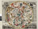
| Date: | 1745 |
|---|---|
| Description: | Zodiac as seen from the Northern Hemisphere. |
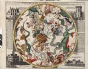
| Date: | 1745 |
|---|---|
| Description: | Zodiac as seen from the Southern Hemisphere. |
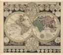
| Date: | 1745 |
|---|---|
| Description: | A two page world map featuring the Eastern and Western Hemispheres, as well as the northern and southern zodiacs. Additionally, the map is ordained with n... |
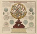
| Date: | 1745 |
|---|---|
| Description: | A two page illustration featuring a small globe in the center of numerous astrological spheres. Additionally, the representation features writing, in Lati... |

| Date: | 1746 |
|---|---|
| Description: | This world map from the German mathematician, historian, and geographer Johann Matthias Hase shows the major cities, islands, and the major political divis... |

| Date: | 1746 |
|---|---|
| Description: | Detailed map of the western hemisphere and part of Africa and Europe. Islands, cities, settlements, rivers, lakes, countries, and regions are marked. Mount... |
If you didn't find the material you searched for, our Library Reference Staff can help.
Call our reference desk at 608-264-6535 or email us at: