 Filter: Categories of Wisconsin Historical Images
Filter: Subject of Schools
Filter: Year of 1900-1999
Filter: Year of 1970-1979
Filter: Subject of human settlements
Filter: Categories of Wisconsin Historical Images
Filter: Subject of Schools
Filter: Year of 1900-1999
Filter: Year of 1970-1979
Filter: Subject of human settlements

| Date: | 1976 |
|---|---|
| Description: | A street map of Milwaukee County, Wisconsin that identifies the location of schools, hospitals, parks, beaches, streets, freeways, both planned or under co... |

| Date: | 1970 |
|---|---|
| Description: | This pictorial map of Dunn County, Wisconsin, from the 1970s depicts historical events that occurred in the county. It shows cemeteries, churches, schools,... |

| Date: | 1970 |
|---|---|
| Description: | This map shows lot and block numbers, city limits, cemeteries, schools, outdoor theater, Lumberjack Bowl, and Historyland among other attractions. |

| Date: | 1973 |
|---|---|
| Description: | This map includes an index of streets and schools and also shows parks, schools and public lands, and industrial sites. Portions of the map are in green an... |

| Date: | 1974 |
|---|---|
| Description: | This map shows streets, Lake Winnebago, Little Lake Butte Des Morts, and the Fox River. Also included is text on the Fox River Waterways and the history of... |

| Date: | 1970 |
|---|---|
| Description: | This map shows roads, parks, swimming beaches, golf courses, yacht harbors, light houses, airports, public hunting grounds, waysides, schools, and fishing ... |
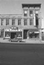
| Date: | 1973 |
|---|---|
| Description: | View across King Street towards The Gallery Inn restaurant, on the left, and the Buy Sell shop with a show window on the corner of King and Webster streets... |
If you didn't find the material you searched for, our Library Reference Staff can help.
Call our reference desk at 608-264-6535 or email us at: