 Filter: Categories of Wisconsin Historical Images
Filter: Subject of Schools
Filter: Year of 1900-1999
Filter: Year of 1970-1979
Filter: Creator Name of Unknown
Filter: Categories of Wisconsin Historical Images
Filter: Subject of Schools
Filter: Year of 1900-1999
Filter: Year of 1970-1979
Filter: Creator Name of Unknown

| Date: | 1978 |
|---|---|
| Description: | Teacher Dorothy Ledin teaching numbers to two pre-schoolers using a board with removable numbers and dots at Ellis School. |
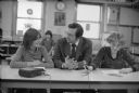
| Date: | 1978 |
|---|---|
| Description: | Congressman David R. Obey of Wisconsin (center) holding a press conference about federal funding for education with students at Ellis School. A few journal... |

| Date: | 1970 |
|---|---|
| Description: | This map shows lot and block numbers, city limits, cemeteries, schools, outdoor theater, Lumberjack Bowl, and Historyland among other attractions. |

| Date: | 1973 |
|---|---|
| Description: | This map includes an index of streets and schools and also shows parks, schools and public lands, and industrial sites. Portions of the map are in green an... |

| Date: | 1974 |
|---|---|
| Description: | Logo on a Wisconsin Education Association Council brochure related to the Hortonville teachers strike. |

| Date: | 1970 |
|---|---|
| Description: | This map shows roads, parks, swimming beaches, golf courses, yacht harbors, light houses, airports, public hunting grounds, waysides, schools, and fishing ... |
If you didn't find the material you searched for, our Library Reference Staff can help.
Call our reference desk at 608-264-6535 or email us at: