 Filter: Categories of Wisconsin Historical Images
Filter: Subject of Schools
Filter: Year of 1900-1999
Filter: Subject of church buildings
Filter: Categories of Wisconsin Historical Images
Filter: Subject of Schools
Filter: Year of 1900-1999
Filter: Subject of church buildings

| Date: | 06 28 1951 |
|---|---|
| Description: | Children sitting on the floor and working on art projects at tables in the nursery school at the First Unitarian Society Meeting House. The building was de... |

| Date: | 11 18 1955 |
|---|---|
| Description: | Patricia Mathisen (Mrs. George), member of Kappa Kappa Gamma sorority alumnae group, sponsor of the Nursery School for Slow Learners at the First Congregat... |

| Date: | 11 18 1955 |
|---|---|
| Description: | Dorcas Nichles (Mrs. Robert J., Jr.), member of Kappa Kappa Gamma sorority alumnae group who sponsored the Nursery School for Slow Learners at the First Co... |

| Date: | 06 24 1946 |
|---|---|
| Description: | Group portrait of the 8th grade graduation class, St. Raphael's Catholic School, 216 West Main Street. Pictured are the forty-seven graduates and a priest. |

| Date: | 06 09 1948 |
|---|---|
| Description: | Group portrait of the eighth grade graduating class of St. Raphael Catholic School, 216 West Main Street, with a nun and a priest. |

| Date: | 1913 |
|---|---|
| Description: | A wall atlas of Sauk County, Wisconsin, displaying its 22 towns. On the left side are advertisements for local businesses. |

| Date: | 1912 |
|---|---|
| Description: | View across road of a Norwegian Church, and a Public School next door. The church building features a tall steeple, lancet arched windows, gable roof, and ... |

| Date: | 1943 |
|---|---|
| Description: | A map that shows the lands for sale by the Tomahawk Land Company of Tomahawk, Wisconsin, in the counties of Langlade, Lincoln, Oneida, and Price. The map s... |

| Date: | 1922 |
|---|---|
| Description: | View across street of Saint Mary's Church and School. |
| Date: | 1908 |
|---|---|
| Description: | This map shows townships and sections, landownership, schools, and churches. Includes text explaining survey system. |

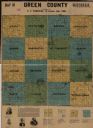
| Date: | 1926 |
|---|---|
| Description: | A topographic map of Green County, showing by contours and spot heights the topographic and natural features of the county. The contour intervals are 20 fe... |

| Date: | 1946 |
|---|---|
| Description: | A map showing the roads, railroads, towns, cities and villages, streams and lakes, airports, schools, churches, cemeteries, and golf courses in Kenosha Cou... |

| Date: | 1908 |
|---|---|
| Description: | A map of Langlade County, Wisconsin that shows the townships and ranges, towns, cities and villages, wagon roads, churches, schools, lakes, rivers, railroa... |

| Date: | 1909 |
|---|---|
| Description: | A map of Langlade County, Wisconsin that shows townships and ranges, towns, cities and villages, wagon roads, churches, schools, sawmills, town halls, chee... |

| Date: | 1915 |
|---|---|
| Description: | This 1915 map of Lincoln County, Wisconsin, shows the township and range grid, towns, cities and villages, lakes and streams, residences, churches, school ... |

| Date: | 1926 |
|---|---|
| Description: | A map of Lincoln County, Wisconsin that shows the township and range grid, towns, cities and villages, lakes and streams, residences, churches, school hous... |

| Date: | 1900 |
|---|---|
| Description: | A map of Marinette County, Wisconsin shows the township and range system, sections, towns, cities and villages, streams and lakes, railroads, roads, school... |

| Date: | 1902 |
|---|---|
| Description: | A map of Milwaukee County, Wisconsin that shows the township and range system, sections, towns, roads, railroads and rail stations, cities and villages, po... |

| Date: | 1922 |
|---|---|
| Description: | This map from the early to mid-20th century shows the township and range system, towns, cities and villages, roads, railroads, schools, churches, cemeterie... |
If you didn't find the material you searched for, our Library Reference Staff can help.
Call our reference desk at 608-264-6535 or email us at:
