Filter: Categories of Wisconsin Historical Images
Filter: Subject of Schools
Filter: Year of 1800-1899
Filter: Year of 1870-1879
Filter: Categories of Wisconsin Historical Images
Filter: Subject of Schools
Filter: Year of 1800-1899
Filter: Year of 1870-1879
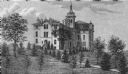
| Date: | 1872 |
|---|---|
| Description: | Alleged to be the earliest known view of St. Mary's Institute, which later became St. Mary's College. One-half of a stereograph. |

| Date: | 1872 |
|---|---|
| Description: | Birds-eye drawing of Eau Claire depicts street names and street locations, houses, trees, bridges, piers, canals, railroads, and the Chippewa and Eau Clair... |

| Date: | 1874 |
|---|---|
| Description: | Bird's-eye map of Lodi, with inset of Public School. Includes index of churches and points of interest. |

| Date: | 1879 |
|---|---|
| Description: | This map is a bird's-eye view of Wausau, the County Seat of Marathon County. The map features an index of points of interest. |
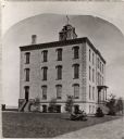
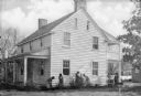
| Date: | 1870 |
|---|---|
| Description: | Two-story brick building built in 1870 with arched windows, corner brackets, bell tower with elaborate cut work, four chimneys and fence in front. Inscript... |
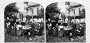
| Date: | 1877 |
|---|---|
| Description: | F.A. Schmidt, professor of theology at the Norwegian Lutheran Seminary, with his family on the grounds of the seminary, formerly the Soldiers' and Orphans'... |
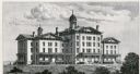
| Date: | 1876 |
|---|---|
| Description: | The Institution for the Education of the Blind. |
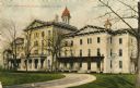
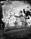
| Date: | 1870 |
|---|---|
| Description: | The State Institute for the Blind, a school free for blind children of Wisconsin. Caption reads: "State Institute for Blind, Janesville, Wis." |
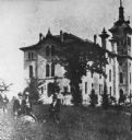
| Date: | 1870 |
|---|---|
| Description: | State Normal School. A group of men are standing in the tall grass in the left foreground. |
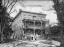
| Date: | 1872 |
|---|---|
| Description: | A view of the female residence at Hampton Institute. The left side of the front porch contains potted plant,s and three women converse near the steps. Anot... |
| Date: | 1872 |
|---|---|
| Description: | Female students garden next to the Home Economics Practice House. The house has clapboard siding on its two stories and there is a porch on the front and b... |
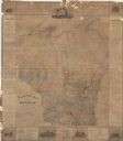
| Date: | 1876 |
|---|---|
| Description: | This map is ink on paper and shows the location of various types of schools. The map includes text about the school system and tables of statistics (1849-1... |

| Date: | 1870 |
|---|---|
| Description: | A map of Iowa County, Wisconsin mounted on cloth that shows the villages of Avoca, Mifflin, Linden, Arena, Helena Station, Highland, Dodgeville, as well as... |

| Date: | 1877 |
|---|---|
| Description: | A map of Monroe County, Wisconsin that shows the townships and landownership and acreage wagon roads, railroads, streams, schools, and houses. Also include... |

| Date: | 1876 |
|---|---|
| Description: | This 1876 map of Saint Croix County, Wisconsin, shows the township and range grid, sections, towns, cities and villages, land ownership and acreages, wagon... |

| Date: | 1877 |
|---|---|
| Description: | This 1877 map of Sauk County, Wisconsin, shows the township and range grid, sections, towns, cities and villages, land ownership and acreages, wagon roads,... |

| Date: | 1871 |
|---|---|
| Description: | This map of Barron County, Wisconsin, shows the township and range grid, towns, sections, cities and villages, post offices, dwellings, schools, roads, swa... |
If you didn't find the material you searched for, our Library Reference Staff can help.
Call our reference desk at 608-264-6535 or email us at: