 Filter: Categories of Wisconsin Historical Images
Filter: Subject of Schools
Filter: Year of 1800-1899
Filter: Year of 1860-1869
Filter: Categories of Wisconsin Historical Images
Filter: Subject of Schools
Filter: Year of 1800-1899
Filter: Year of 1860-1869

| Date: | 1867 |
|---|---|
| Description: | Birds-eye drawing of Beaver Dam, Dodge Co., depicting street names and street layout, houses, rivers, lakes, and trees. A reference key at the bottom of th... |

| Date: | 1867 |
|---|---|
| Description: | Bird's-eye map of Berlin, with insets of West Side Public School and High School. |

| Date: | 1869 |
|---|---|
| Description: | Birds-eye drawing of Boscobel, Grant County, depicts street names and street layouts, houses, rivers and trees. A reference key at the bottom of the map sh... |

| Date: | 1867 |
|---|---|
| Description: | Bird's-eye map of Green Bay and Fort Howard, Brown Co., depicts street names and street layouts, houses, trees, and the East River. A reference key at the ... |

| Date: | 1867 |
|---|---|
| Description: | Bird's-eye map of La Crosse with nine insets of residences, schools, and the Court House and Jail. |
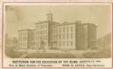
| Date: | 1865 |
|---|---|
| Description: | The Institution for the Education of the Blind. Caption reads: "Institution for the Education of the Blind, Janesville, Wisc. Free to Blind Children of Wis... |
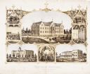
| Date: | 1867 |
|---|---|
| Description: | 1868-1875. Founded by Dr. Joseph Salzman (featured in the vignette at left, teaching). Vignette, lower left, features St. Francis Seminary, founded in 1856... |
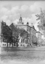
| Date: | 1864 |
|---|---|
| Description: | View across lawn toward the stone facade of St. Mary Academy. The arched main entrance is partially behind trees on the left. A bell tower sits in the midd... |

| Date: | 1868 |
|---|---|
| Description: | A detailed, cloth mounted map of Grant County that shows the townships, towns, roads, completed and under construction railroads, cemeteries, mills, lead m... |

| Date: | 1862 |
|---|---|
| Description: | This 1862 map of Sheboygan County, Wisconsin, shows land ownership and acreages, the township and range grid, towns, cities and villages, roads, railroads,... |

| Date: | 02 13 1869 |
|---|---|
| Description: | Engraved image of several men attempting to ride velocipedes in a large open, interior space. Many have fallen or are struggling with balance. |

| Date: | 1861 |
|---|---|
| Description: | This 1861 map of Columbia County, Wisconsin, shows the township and range grid, towns, sections, cities and villages, railroads, roads, property owners and... |

| Date: | 1862 |
|---|---|
| Description: | This map shows townships and sections, landownership and acreages, roads, railroads, cemeteries, churches, schools, mills, and stone quarries. "Engraved, p... |

| Date: | 1860 |
|---|---|
| Description: | This map shows roads, railroads, rivers, townships, school houses, churches, cemeteries, and land ownership by name. Relief is shown by hachures. The map i... |

| Date: | 1861 |
|---|---|
| Description: | This map shows townships and sections, landownership, roads, railroads, rural residences, schools, churches, and topography. Also included are inset maps o... |
If you didn't find the material you searched for, our Library Reference Staff can help.
Call our reference desk at 608-264-6535 or email us at: