 Filter: Categories of Wisconsin Historical Images
Filter: Subject of Schools
Filter: Year of 1800-1899
Filter: Categories of Wisconsin Historical Images
Filter: Subject of Schools
Filter: Year of 1800-1899

| Date: | 1884 |
|---|---|
| Description: | Class picture of the fourth ward pupils of Madison. 1. Caroline Young, 2. Belle Griffiths 3. Carrie Kohner 4. Irma Kleinpell 5. Annie McConnell 6. Matie Ja... |

| Date: | 1884 |
|---|---|
| Description: | 1. ? Rarnsdall 2. Florence Ketchem 3. Hattie Stephenson 4. ? Carver 5. Addie McConnell 6. Delia Lawerence 7. Madeline Slightam 8. Annie Kingston 9. Maud Va... |

| Date: | 1889 |
|---|---|
| Description: | Eight diagrams that describe the topography and vegetation of school sections in the towns of Clear Creek and Ludington in Eau Claire County; Sigel in Chip... |

| Date: | 1880 |
|---|---|
| Description: | A hand-colored map of the Chippewa, Price, Taylor and the northern part of Clark counties, which shows the locations of farmhouses, schoolhouses, churches,... |

| Date: | 1881 |
|---|---|
| Description: | A brochure with a map of Wisconsin that also includes information (in English, German, Norwegian, and Swedish) pertaining to the state, such as its timber ... |

| Date: | 05 1846 |
|---|---|
| Description: | Hand-colored map of southeastern Wisconsin showing the counties of Dodge, Jefferson, Rock, Walworth, Racine (including modern-day Kenosha County), Waukesha... |
| Date: | 1876 |
|---|---|
| Description: | This map is ink on paper and shows the location of various types of schools. The map includes text about the school system and tables of statistics (1849-1... |

| Date: | 1895 |
|---|---|
| Description: | The front (left) and back (right) of a promotional card advertising farming land in northern Wisconsin. The caption below the image reads: "A typical cou... |

| Date: | 1895 |
|---|---|
| Description: | Promotional card advertising the school house in Rib Lake. The caption reads, "SCHOOL HOUSE, RIB LAKE, TAYLOR COUNTY, WIS. -In all the towns of Price and T... |

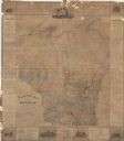
| Date: | 1868 |
|---|---|
| Description: | A detailed, cloth mounted map of Grant County that shows the townships, towns, roads, completed and under construction railroads, cemeteries, mills, lead m... |

| Date: | 1895 |
|---|---|
| Description: | View across road towards the exterior of a brick elementary school in northern Wisconsin. A large group of children and adults pose from within the schooly... |

| Date: | 1896 |
|---|---|
| Description: | A map of Green Lake County, Wisconsin, shows township divisions, villages and post offices, railroads, roads, lakes and streams, schools, and churches. |

| Date: | 1870 |
|---|---|
| Description: | A map of Iowa County, Wisconsin mounted on cloth that shows the villages of Avoca, Mifflin, Linden, Arena, Helena Station, Highland, Dodgeville, as well as... |

| Date: | 1896 |
|---|---|
| Description: | A map of Iron County, Wisconsin, shows vacant Wisconsin Central Rail Road lands, settlers houses, land sold by Wisconsin Central R.R., schools, churches, s... |

| Date: | 1898 |
|---|---|
| Description: | A map of Iron County, Wisconsin, shows vacant Wisconsin Central Rail Road lands, settlers houses, land sold by Wisconsin Central R.R., schools, churches, s... |

| Date: | 1896 |
|---|---|
| Description: | A hand-colored Map of Jefferson County, Wisconsin, shows township and section divisions, towns, villages and post offices, rural residents, railroads, road... |

| Date: | 1886 |
|---|---|
| Description: | A hand-colored map of Milwaukee County, Wisconsin that shows the township and range system, sections, towns, roads, railroads and rail stations, cities and... |

| Date: | 1891 |
|---|---|
| Description: | A hand-colored map of Milwaukee County, Wisconsin that shows the township and range system, sections, towns, roads, railroads and rail stations, cities and... |

| Date: | 1896 |
|---|---|
| Description: | A map of Milwaukee County, Wisconsin that shows the township and range system, sections, towns, roads, railroads and rail stations, cities and villages, po... |

| Date: | 1877 |
|---|---|
| Description: | A map of Monroe County, Wisconsin that shows the townships and landownership and acreage wagon roads, railroads, streams, schools, and houses. Also include... |
If you didn't find the material you searched for, our Library Reference Staff can help.
Call our reference desk at 608-264-6535 or email us at: