 Filter: Categories of Wisconsin Historical Images
Filter: Subject of Schools
Filter: Year of 1800-1899
Filter: Categories of Wisconsin Historical Images
Filter: Subject of Schools
Filter: Year of 1800-1899

| Date: | 1896 |
|---|---|
| Description: | This 1896 map of Washburn County, Wisconsin, shows the township and range grid, sections, schools, wagon roads, cities and villages, settlers, railroads, a... |

| Date: | 1882 |
|---|---|
| Description: | This 1882 map of Barron County, Wisconsin, shows the township and range grid, towns, cities and villages, wagon roads, railroads, schools, dwellings, and l... |

| Date: | 1870 |
|---|---|
| Description: | This 1870 map of Brown County, Wisconsin, shows the township and range grid, towns, sections, cities, villages and post offices, land ownership, roads, rai... |

| Date: | 1896 |
|---|---|
| Description: | This map of Brown County, Wisconsin, from the late 19th century shows land claims along the Fox River, the township and range grid, towns, sections, cities... |

| Date: | 02 13 1869 |
|---|---|
| Description: | Engraved image of several men attempting to ride velocipedes in a large open, interior space. Many have fallen or are struggling with balance. |

| Date: | 1861 |
|---|---|
| Description: | This 1861 map of Columbia County, Wisconsin, shows the township and range grid, towns, sections, cities and villages, railroads, roads, property owners and... |

| Date: | 1878 |
|---|---|
| Description: | This map of Crawford County, Wisconsin, shows the township and range grid, sections, towns, cities and villages, land ownership and acreages, roads, railro... |

| Date: | 1896 |
|---|---|
| Description: | This late 19th-century map of Dodge County, Wisconsin, shows the township and range grid, towns, sections, cities, villages and post offices, some property... |

| Date: | 1862 |
|---|---|
| Description: | This map shows townships and sections, landownership and acreages, roads, railroads, cemeteries, churches, schools, mills, and stone quarries. "Engraved, p... |

| Date: | 1873 |
|---|---|
| Description: | This late 19th century map shows the lake region around Oconomowoc in Waukesha County and eastern Jefferson County, Wisconsin. The township and range grid,... |

| Date: | 1898 |
|---|---|
| Description: | Map showing the contour depths of the lakes in northwestern Waukesha County, Wisconsin. Roads, railroads, depots, churches, schools, and hotels in the area... |
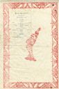
| Date: | 06 28 1887 |
|---|---|
| Description: | Menu for a senior reception catered by W.H. Burleson, with a wide border of pig or demon half-faces, and in the center a figure in a kimono and sandals wit... |

| Date: | 1859 |
|---|---|
| Description: | This map show plats including plat names, plat numbers, and some lot owner's names. Relief is shown by hachures. The map includes line drawings of Juneau B... |

| Date: | 1886 |
|---|---|
| Description: | This map has relief shown by hachures and includes a list of plats in order of date of record, laws which vacate plats, plats not shown as upon the county ... |

| Date: | 1888 |
|---|---|
| Description: | This map has relief shown by hachures and features inset maps of a plat of E.D. Clinton and Blackwell’s add’n to the City of La Crosse. Wards (1-10) shaded... |

| Date: | 1873 |
|---|---|
| Description: | This map shows landownership and acreages, lot and block numbers, roads and railroads, marshes, schools, churches, mills, rural buildings, and quarries. Re... |

| Date: | 1876 |
|---|---|
| Description: | A hand-colored map on six sheets, this map of Juneau County indicates the locations of townships and sections, landowners and acreages, roads, wagon roads,... |

| Date: | 1858 |
|---|---|
| Description: | This map is hand-colored and mounted on cloth and shows lot and block numbers and dimensions, landownership, streets, railroads, selected buildings, fair g... |

| Date: | 1894 |
|---|---|
| Description: | The front cover of a booklet about Hillside Home School during 1894-1895, the school's seventh year. |

| Date: | 1895 |
|---|---|
| Description: | Cover of a booklet about Hillside Home School for 1895-1896, the school's eighth year. Includes a circular framed photograph of the front of the school. |
If you didn't find the material you searched for, our Library Reference Staff can help.
Call our reference desk at 608-264-6535 or email us at: