 Filter: Categories of Wisconsin Historical Images
Filter: Subject of Schools
Filter: Subject of human settlements
Filter: Community of Milwaukee
Filter: Categories of Wisconsin Historical Images
Filter: Subject of Schools
Filter: Subject of human settlements
Filter: Community of Milwaukee
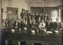
| Date: | 1912 |
|---|---|
| Description: | Marquette University, School of Pharmacy, Class of 1912. Rial Herreman is identified as the third from the left in the back row. |
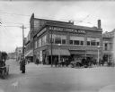
| Date: | 04 01 1915 |
|---|---|
| Description: | Northwest corner of 3rd and Wells Street, facing the Milwaukee Commercial School. A police officer directs traffic in the foreground, with pedestrians on t... |
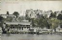
| Date: | |
|---|---|
| Description: | Color postcard of a bathing place on the water. A hill is behind the building, and there are a signs for a swimming school and the Wm. Bechstein Co. Severa... |
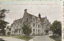
| Date: | 1906 |
|---|---|
| Description: | Administration building for the school. The building has over three stories, and a covered main entrance. Caption reads: "Administration Building, Industri... |
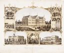
| Date: | 1867 |
|---|---|
| Description: | 1868-1875. Founded by Dr. Joseph Salzman (featured in the vignette at left, teaching). Vignette, lower left, features St. Francis Seminary, founded in 1856... |
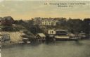
| Date: | 1910 |
|---|---|
| Description: | Elevated view from bridge looking over at a hill leading down to bath houses and fenced-in swimming areas for beginners. Establishment of Wm. Bechstein. Ca... |

| Date: | 1886 |
|---|---|
| Description: | A hand-colored map of Milwaukee County, Wisconsin that shows the township and range system, sections, towns, roads, railroads and rail stations, cities and... |

| Date: | 1891 |
|---|---|
| Description: | A hand-colored map of Milwaukee County, Wisconsin that shows the township and range system, sections, towns, roads, railroads and rail stations, cities and... |

| Date: | 1902 |
|---|---|
| Description: | A map of Milwaukee County, Wisconsin that shows the township and range system, sections, towns, roads, railroads and rail stations, cities and villages, po... |
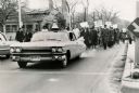
| Date: | 1964 |
|---|---|
| Description: | A group of protesters march down a street, led by a car. They are protesting school segregation. |

| Date: | 1892 |
|---|---|
| Description: | This map shows schools, engine houses, railroads, street railways, wards, parks, cemeteries, block numbers, a street index, explanations, and general refer... |

| Date: | 1901 |
|---|---|
| Description: | This map shows public schools, engine houses, railroads, street railways, city wards, parks, block numbers, and Lake Michigan. Also included are indexes, t... |

| Date: | 1904 |
|---|---|
| Description: | This map has three inset maps of Whitefish Bay, Cudahy, and South Milwaukee. This map depicts schools, engine houses, railroads, street railways, city ward... |

| Date: | 1904 |
|---|---|
| Description: | This map shows wards, schools, engine houses, railroads, street railways, block numbers, parks, roads, and Lake Michigan. Also included are indexes: Table ... |

| Date: | 1924 |
|---|---|
| Description: | This map shows streets, selected buildings, railroads, railway yards, schools, parks, schools, cemeteries, bays, the Milwaukee River, and Lake Michigan. De... |

| Date: | 1927 |
|---|---|
| Description: | This map shows street car lines, bus routes, railroads, proposed city boundary lines, wards, public schools, blocks & house numbers, Lake Michigan, one mil... |

| Date: | 1956 |
|---|---|
| Description: | This map shows city, suburban, parochial and other types schools, with an explanation of symbols in the right margin. The original caption for the map read... |

| Date: | 1966 |
|---|---|
| Description: | This map shows city, suburban, parochial and other types schools, with an explanation of symbols in the right margin. The original caption for the map read... |
If you didn't find the material you searched for, our Library Reference Staff can help.
Call our reference desk at 608-264-6535 or email us at: