Filter: Categories of Wisconsin Historical Images
Filter: Subject of Schools
Filter: County of Racine
Filter: Categories of Wisconsin Historical Images
Filter: Subject of Schools
Filter: County of Racine

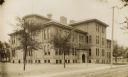
| Date: | 1928 |
|---|---|
| Description: | Exterior view of an English settlement school. |

| Date: | 1858 |
|---|---|
| Description: | This 1858 map of Racine County, Wisconsin, shows land ownership and acreages, the township and range grid, towns, cities and villages, roads, railroads, sc... |

| Date: | 1896 |
|---|---|
| Description: | This 1896 map of Racine and Kenosha counties, Wisconsin, shows the township and range grid, towns, sections, cities, villages and post offices, roads, rail... |

| Date: | 1911 |
|---|---|
| Description: | This 1911 map shows the Post Office's rural routes in Racine County, Wisconsin, and portions of eastern Walworth and northern Kenosha counties. The locatio... |

| Date: | 1858 |
|---|---|
| Description: | This map shows lot and block numbers, landownership, buildings, railroads, roads, wards, points of interest, parks, and cemeteries. Also included are illus... |
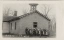
| Date: | 1918 |
|---|---|
| Description: | Students and teachers posing for a group portrait at the entrance of their school. There is a bell tower on the roof. Caption reads: "Franksville, Wis." |

| Date: | 1887 |
|---|---|
| Description: | A plat map of Waterford. Township 4, North Range 19, East of 4th Principal Meridian. References at bottom include school houses, houses, churches and cemet... |
If you didn't find the material you searched for, our Library Reference Staff can help.
Call our reference desk at 608-264-6535 or email us at: