 Filter: Categories of Wisconsin Historical Images
Filter: Subject of Schools
Filter: County of Milwaukee
Filter: Year of 1900-1999
Filter: Categories of Wisconsin Historical Images
Filter: Subject of Schools
Filter: County of Milwaukee
Filter: Year of 1900-1999

| Date: | 05 30 1904 |
|---|---|
| Description: | Chromolithograph of Old Abe, Wisconsin War Eagle. The title reads: "Memorial Day in Wisconsin Schools." |
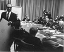
| Date: | 01 21 1964 |
|---|---|
| Description: | Lloyd Barbee, NAACP state president, walking out of a Milwaukee Public School Board meeting when Chairman Harold W. Story refused to allow the participatio... |
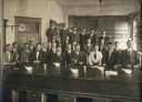
| Date: | 1912 |
|---|---|
| Description: | Marquette University, School of Pharmacy, Class of 1912. Rial Herreman is identified as the third from the left in the back row. |

| Date: | 09 10 1983 |
|---|---|
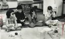
| Description: | Liz Walden looks over empty boxes of laundry soap collected in a Refund Swap Convention at Our Lady of Good Hope School. |

| Date: | 12 18 1963 |
|---|---|
| Description: | A craft class member of Milwaukee public school system's recreation department frosting a gingerbread cookie house at the Grant Street social center. |
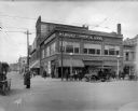
| Date: | 04 01 1915 |
|---|---|
| Description: | Northwest corner of 3rd and Wells Street, facing the Milwaukee Commercial School. A police officer directs traffic in the foreground, with pedestrians on t... |
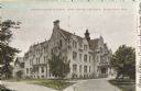
| Date: | 1906 |
|---|---|
| Description: | Administration building for the school. The building has over three stories, and a covered main entrance. Caption reads: "Administration Building, Industri... |
| Date: | 1910 |
|---|---|
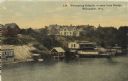
| Description: | Elevated view from bridge looking over at a hill leading down to bath houses and fenced-in swimming areas for beginners. Establishment of Wm. Bechstein. Ca... |
| Date: | 03 27 1989 |
|---|---|
| Description: | Laura Allaway, Daniel Hirsh, Sarah Dionisopolous, and Abigail Lank enjoying a picnic and beach party during the Family After School Program at Henry Clay E... |

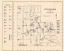
| Date: | 1902 |
|---|---|
| Description: | A map of Milwaukee County, Wisconsin that shows the township and range system, sections, towns, roads, railroads and rail stations, cities and villages, po... |

| Date: | 1976 |
|---|---|
| Description: | A street map of Milwaukee County, Wisconsin that identifies the location of schools, hospitals, parks, beaches, streets, freeways, both planned or under co... |

| Date: | 1993 |
|---|---|
| Description: | A map of Milwaukee County, indicating the locations of toxic sites and the types of toxic sites, ranging from those listed as a superfund site, industry re... |

| Date: | 1964 |
|---|---|
| Description: | A group of protesters march down a street, led by a car. They are protesting school segregation. |

| Date: | 1960 |
|---|---|
| Description: | This map of Greedale shows local streets, parks, schools, and churches and includes manuscript annotations in green and blue showing tracts and parcels of ... |

| Date: | 1932 |
|---|---|
| Description: | This map of Granville shows streets, businesses, residential areas, schools, golf courses, and industrial areas. The map shows Granville in March of 1932. ... |

| Date: | 1938 |
|---|---|
| Description: | This map shows buildings, lots, parks, schools, pumping stations, sites reserved for churches, and water towers. |

| Date: | 1964 |
|---|---|
| Description: | This map is a hand-colored blue line print and shows 4 residence zones, 2 business zones, 1 light manufacturing zones, schools, and parks. The zones are ou... |
| Date: | 1965 |
|---|---|
| Description: | This map shows Milwaukee County Parkway lands, streets, streets not yet constructed, public facilities, schools, churches, and manufacturers. The map inclu... |

| Date: | 1901 |
|---|---|
| Description: | This map shows public schools, engine houses, railroads, street railways, city wards, parks, block numbers, and Lake Michigan. Also included are indexes, t... |

| Date: | 1965 |
|---|---|
| Description: | This map shows wards, city limits, railroad right of way, proposed future streets, and approximate street elevations. Wards and public schools are labeled ... |
If you didn't find the material you searched for, our Library Reference Staff can help.
Call our reference desk at 608-264-6535 or email us at: