Filter: Categories of Wisconsin Historical Images
Filter: Subject of School buildings
Filter: Year of 1800-1899
Filter: Year of 1860-1869
Filter: Categories of Wisconsin Historical Images
Filter: Subject of School buildings
Filter: Year of 1800-1899
Filter: Year of 1860-1869
| Date: | 1865 |
|---|---|
| Description: | University of Wisconsin-Madison campus showing the first three buildings on campus, South Hall (left), University Hall [Bascom Hall] (center), and North Ha... |

| Date: | 1868 |
|---|---|
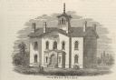
| Description: | Illustration of the exterior of the Second Ward School House, copied from the 1868 Madison City Directory. |

| Date: | 1868 |
|---|---|
| Description: | Bird's-eye map of Portage, with insets of the Court House and the Public School. |
| Date: | 1860 |
|---|---|
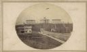
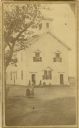
| Description: | Front entry to the Wesleyan Seminary. It was built in the early 1860's on the site of the present High School building. |
| Date: | 1865 |
|---|---|
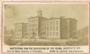
| Description: | The Institution for the Education of the Blind. Caption reads: "Institution for the Education of the Blind, Janesville, Wisc. Free to Blind Children of Wis... |
| Date: | 1869 |
|---|---|
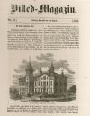
| Description: | Cover of Billed-Magazin. featuring an engraved view of The Jefferson Liberal Institute. |
| Date: | 1860 |
|---|---|
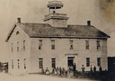
| Description: | Elevated view of the Third Ward school, with students in front. |
| Date: | 1860 |
|---|---|
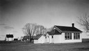
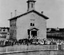
| Description: | The first high school erected in Palmyra, built about 1860. People are standing in the yard. |
| Date: | 01 23 1869 |
|---|---|
| Description: | Second Ward School with a teacher and students in the schoolyard. |
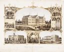
| Date: | 1867 |
|---|---|
| Description: | 1868-1875. Founded by Dr. Joseph Salzman (featured in the vignette at left, teaching). Vignette, lower left, features St. Francis Seminary, founded in 1856... |

| Date: | 1862 |
|---|---|
| Description: | This 1862 map of Winnebago County, Wisconsin, shows the township and range grid, towns, sections, cities and villages, railroads, roads, property owners an... |

| Date: | 1862 |
|---|---|
| Description: | Shows townships and sections, landownership and acreage, roads, railroads, churches, schools, and cemeteries. Inset maps: Plat of Hingham -- Plat of Casca... |

| Date: | 1863 |
|---|---|
| Description: | Includes index to public buildings, churches, schools. Inset: Glidden & Lockwood’s addition. Gives names of some property owners. |

| Date: | 1867 |
|---|---|
| Description: | View across street towards the front of the 2nd Ward School building, which was located at 720 E. Gorham Street. |
If you didn't find the material you searched for, our Library Reference Staff can help.
Call our reference desk at 608-264-6535 or email us at: