 Filter: Categories of Wisconsin Historical Images
Filter: Subject of School buildings
Filter: Year of 1800-1899
Filter: Categories of Wisconsin Historical Images
Filter: Subject of School buildings
Filter: Year of 1800-1899

| Date: | 1862 |
|---|---|
| Description: | Shows townships and sections, landownership and acreage, roads, railroads, churches, schools, and cemeteries. Inset maps: Plat of Hingham -- Plat of Casca... |

| Date: | 1899 |
|---|---|
| Description: | This 1899 map of Dodge County, Wisconsin, shows the township and range grid, towns, sections, cities and villages, roads, railroads, post offices, cemeteri... |

| Date: | 1896 |
|---|---|
| Description: | This 1896 map of Douglas County, Wisconsin, shows the township and range grid, the towns of Superior, Brule, Gordon, and Nebagamain, sections, cities and v... |

| Date: | 1858 |
|---|---|
| Description: | This 1858 map of Rock County, Wisconsin, shows the township and range grid, towns, sections, cities and villages, railroads, roads, property owners and res... |
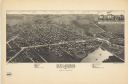
| Date: | 1884 |
|---|---|
| Description: | This map is a Birdseye view of Delavan, Wisconsin. At the bottom of the map are points of interest that correspond to numbers on the map. Many of the stree... |

| Date: | 1863 |
|---|---|
| Description: | Includes index to public buildings, churches, schools. Inset: Glidden & Lockwood’s addition. Gives names of some property owners. |

| Date: | 1889 |
|---|---|
| Description: | Shows city limits, railroads, mills, schools, cemeteries, dams, parks, lumber yards, log canals, log reservoir, Chippewa River, Eau Claire River, and Half ... |

| Date: | 1888 |
|---|---|
| Description: | Shows ward divisions and street railways, as well as University of Wisconsin buildings, churches, and schools. Cataloged from copy with right and left edge... |

| Date: | 1872 |
|---|---|
| Description: | Shows townships and sections, landownership and acreages, roads, railroads, churches, schools, and cemeteries. Includes business directories of Manitowoc ... |

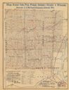
| Date: | 1892 |
|---|---|
| Description: | Map shows farms, schools, saw mills, townships, railroads, and roads. Counties are labelled and are outlined in yellow and pink. On the upper right and le... |

| Date: | 1831 |
|---|---|
| Description: | Map of the city of Louisville, Kentucky on the Ohio River showing streets and numbered lots. The Ohio River, Corn Island, and the Louisville and Portland C... |
| Date: | 1890 |
|---|---|
| Description: | The map shows roads and railroads, houses, schools, town halls, and other points of interest in parts of Shawano, Oconto, and Brown counties. The lower lef... |

| Date: | 1873 |
|---|---|
| Description: | Map shows townships and sections, landownership and acreages, state and county lands, churches, schools, cemeteries, roads, and railroads. There is an inse... |

| Date: | 1872 |
|---|---|
| Description: | Map shows townships and sections, landownership, roads, railroads, churches, schools, and cemeteries. The map includes business directories of Watertown, J... |

| Date: | 1857 |
|---|---|
| Description: | Map of La Crosse County, Wisconsin showing village plat, farm houses, schools, roads, railroads, township names (New Amsterdam, Dacota, Minnesota, Driesbac... |

| Date: | 1874 |
|---|---|
| Description: | Bird's-eye view map of Appleton, Wisconsin. Map reads: "NOTE.-Since the above cut was engraved, the Fox River Pulp & Paper Co.'s Mammoth Mills have been er... |
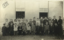
| Date: | 1898 |
|---|---|
| Description: | Outdoor class group portrait of the 5th and 6th grades of Muscoda Public School. An "X" marks Emma Schmitt (the future Mrs. Sherwin Gillett). Boys kneel in... |

| Date: | 1878 |
|---|---|
| Description: | This bird’s-eye-view map of Barton is indexed for parochial and public schools, churches, a convent, the railroad depot, and the post office. |
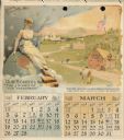
| Date: | 1893 |
|---|---|
| Description: | Calendar with the months of February and March, 1893. Features an illustration of a woman sitting on the top of a globe. She is holding a wreath, and is re... |
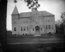
| Date: | 1897 |
|---|---|
| Description: | View across street towards the front of a large brick school building. Identified as the high school built in 1897 in Black River Falls. |
If you didn't find the material you searched for, our Library Reference Staff can help.
Call our reference desk at 608-264-6535 or email us at: