 Filter: Categories of Wisconsin Historical Images
Filter: Subject of School buildings
Filter: Subject of piers
Filter: Categories of Wisconsin Historical Images
Filter: Subject of School buildings
Filter: Subject of piers
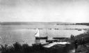
| Date: | 1900 |
|---|---|
| Description: | Elevated view of La Pointe and the shoreline from the Old Mission dock. Two boys and two men stand along the shoreline. The white building with the dark ro... |

| Date: | 1896 |
|---|---|
| Description: | Bird's-eye view of Washburn, with twenty vignettes around side, water in foreground with docks and lumber corral. Thirty-three locations identified in key ... |
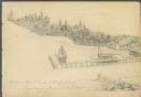
| Date: | 08 24 1885 |
|---|---|
| Description: | Pencil on paper; promontory shoreline with houses, trees, and church in background sweeping to right, with long pier jutting into lake. Two boats tied to ... |

| Date: | 1905 |
|---|---|
| Description: | This early 20th century map of Door County, Wisconsin, shows the township and range grid, towns, sections, cities and villages, landownership and acreages,... |

| Date: | 1968 |
|---|---|
| Description: | Aerial view looking southwest, with Lake Mendota at right and East Gorham Street running from the bottom left corner. Lincoln School is in the foreground, ... |
If you didn't find the material you searched for, our Library Reference Staff can help.
Call our reference desk at 608-264-6535 or email us at: