 Filter: Categories of Wisconsin Historical Images
Filter: Subject of School buildings
Filter: Subject of indian reservations
Filter: Categories of Wisconsin Historical Images
Filter: Subject of School buildings
Filter: Subject of indian reservations
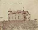
| Date: | 1902 |
|---|---|
| Description: | A Pyramid Lake Agency schoolhouse for Indian children. |
| Date: | |
|---|---|
| Description: | Children outdoors for recess at the Lower Cut Meat Creek School, part of the Rosebud Agency. |
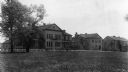
| Date: | 1929 |
|---|---|
| Description: | The Government Indian School in Keshena. |
| Date: | 1929 |
|---|---|
| Description: | The U.S. Department of the Interior, Keshena Indian School. |
| Date: | 1936 |
|---|---|
| Description: | St. Joseph's Indian School on the Keshena Menominee Reservation. |

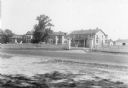
| Date: | 1935 |
|---|---|
| Description: | Menominee Indian Reservation Government School near Shawano. Caption reads: "Government School, Menominee Indian Reservation, Near Shawano, Wis." |

| Date: | 1890 |
|---|---|
| Description: | Stereograph of Presbyterian Mission school grounds in the Chippewa Indian reservation. Building in background, boy walking in field in foreground. |

| Date: | 1890 |
|---|---|
| Description: | Stereograph of Presbyterian Mission school. People gathered in front of building. Fence in foreground of photograph. |

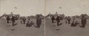
| Date: | 1885 |
|---|---|
| Description: | Stereograph. Probably the Presbyterian Mission School grounds on the Chippewa Indian reservation. Two boys and a dog are standing in the foreground, with a... |

| Date: | 1917 |
|---|---|
| Description: | This 1917 map of Ashland County, Wisconsin, shows the township and range system, towns, sections, cities and villages, the Bad River Indian Reservation, ra... |

| Date: | 1925 |
|---|---|
| Description: | This 1925 map of Ashland County, Wisconsin, shows the township and range system, towns, sections, cities and villages, the Bad River Indian Reservation, ra... |

| Date: | 1890 |
|---|---|
| Description: | This map shows the Wisconsin Central Railroad land grant lands owned and for sale by the Soo Line in Ashland County, Wisconsin, as well as in portions of B... |

| Date: | 1890 |
|---|---|
| Description: | This 1890s map shows the Wisconsin Central Railroad land grant lands owned and for sale by the Soo Line in Ashland County, Wisconsin, as well as in the eas... |

| Date: | 1898 |
|---|---|
| Description: | This 1898 map of Ashland County, Wisconsin, shows the township and range grid, towns, sections, cities and villages, landownership, roads, railroads, swamp... |

| Date: | 1873 |
|---|---|
| Description: | This 1873 map of Chippewa County, Wisconsin, which at the time also encompassed all or part of Price, Rusk, Sawyer, and Taylor counties, shows the township... |

| Date: | 1909 |
|---|---|
| Description: | This map shows vacant Wisconsin Central Ry. lands, settlers houses, lands sold by Wisconsin Central Ry., schools, churches, saw mills, and roads; also show... |
If you didn't find the material you searched for, our Library Reference Staff can help.
Call our reference desk at 608-264-6535 or email us at: