 Filter: Categories of Wisconsin Historical Images
Filter: Subject of School buildings
Filter: Subject of housing
Filter: Categories of Wisconsin Historical Images
Filter: Subject of School buildings
Filter: Subject of housing
| Date: | |
|---|---|
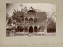
| Description: | A Henry Kendall College cottage, Minerva, for girls. |
| Date: | |
|---|---|
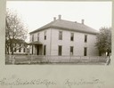
| Description: | Henry Kendall College Boy's Dormitory. |
| Date: | 1910 |
|---|---|
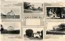
| Description: | Views of Stewart, Wisconsin (otherwise known as Postville or York Township) near Monroe, Dane County. Stewart post-office was established November 12, 186... |
| Date: | 05 13 1961 |
|---|---|
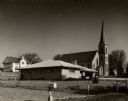
| Description: | Exterior of residence, parochial school, and church. There is a mailbox in the foreground. |

| Date: | 03 06 1948 |
|---|---|
| Description: | Aerial view of High School, in the upper half of the image, with fields, trees, and roadways surrounding it. In the lower half is a residential neighborho... |

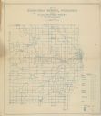
| Date: | 1910 |
|---|---|
| Description: | Map shows routes, post offices, houses, churches, roads, and schools."June 1, 1910. E.G."Blue line print."Walworth Co., Wis. 451" -- bottom margin. |

| Date: | 1911 |
|---|---|
| Description: | This 1911 map from the U.S. Post Office Dept. shows rural delivery routes, active and discontinued post offices, collection boxes, selected rural landowner... |

| Date: | 1908 |
|---|---|
| Description: | Panoramic view of Madison taken from Summit Avenue looking East South East toward Lake Monona. Included in the view are the Camp Randall bleachers, St. Rap... |

| Date: | 1911 |
|---|---|
| Description: | Blue line print. Shows post offices, houses, schools, churches, roads, routes, rivers, and railroads. Includes explanation of symbols. "H.G.M. October 12,... |
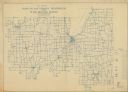
| Date: | 1911 |
|---|---|
| Description: | Shows routes, post offices, churches, houses, schools, roads, and collection boxes. "B. Oct. 11, 1911." Blue line print. "Sheboygan Co., Wis. 587." |

| Date: | 1911 |
|---|---|
| Description: | This 1911 map from the U.S. Post Office Department shows rural delivery routes, active and discontinued post offices, selected rural landowners and houses,... |
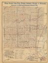
| Date: | 1911 |
|---|---|
| Description: | Shows roads, railroads, post offices, schools, houses, churches, routes, and collection boxes. Includes distant chart and explanation. "Price 35 cents"--... |

| Date: | 1911 |
|---|---|
| Description: | Shows roads, railroads, post offices, schools, houses, churches, and routes. Includes distant chart and explanation. "Price 35 cents"--Upper left margin. "... |
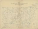
| Date: | 1911 |
|---|---|
| Description: | Map shows routes, post offices, houses, churches, schools, and roads of La Fayette County rural delivery service. The map margins read: "G. January 11, 191... |
| Date: | 1890 |
|---|---|
| Description: | The map shows roads and railroads, houses, schools, town halls, and other points of interest in parts of Shawano, Oconto, and Brown counties. The lower lef... |

| Date: | 1911 |
|---|---|
| Description: | Map shows in blue roads, railroads, post offices, schools, houses, churches, and routes. The map includes a chart of "Explanation" that acts as a legend. T... |

| Date: | 1910 |
|---|---|
| Description: | Map is a blueline print. Map shows United States postal routes for La Crosse County. A list of stations include: Bangor R R 1-3, Holmen R R 1-2, La Crosse ... |

| Date: | 06 12 1929 |
|---|---|
| Description: | This manuscript blueprint shows buildings with the names of their owners, tabernacle, location "where Strang found plates" and "house where Strang died," a... |
If you didn't find the material you searched for, our Library Reference Staff can help.
Call our reference desk at 608-264-6535 or email us at: