 Filter: Categories of Wisconsin Historical Images
Filter: Subject of School buildings
Filter: Subject of farms
Filter: Categories of Wisconsin Historical Images
Filter: Subject of School buildings
Filter: Subject of farms
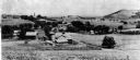
| Date: | 1903 |
|---|---|
| Description: | View down hill of the Enos Lloyd Jones farm with Hillside Home School and Romeo and Juliet in the background. |
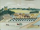
| Date: | 1875 |
|---|---|
| Description: | Seifert's watercolor is fairly large, measuring 27" wide by 21" high, and provides a detailed depiction of a nineteenth century Wisconsin farm. The small s... |
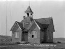
| Date: | 1922 |
|---|---|
| Description: | Exterior of a schoolhouse with a bell tower and flag pole. In the background is a farm, and fields and hills. A sign on the side of the tower says "1903". |

| Date: | 1890 |
|---|---|
| Description: | This map shows the Wisconsin Central Railroad land grant lands owned and for sale by the Soo Line in Ashland County, Wisconsin, as well as in portions of B... |

| Date: | 1890 |
|---|---|
| Description: | This 1890s map shows the Wisconsin Central Railroad land grant lands owned and for sale by the Soo Line in Ashland County, Wisconsin, as well as in the eas... |

| Date: | 1928 |
|---|---|
| Description: | Shows different types of roads, railroads, schools, churches, farmsteads, cheese factories, mine shafts, old surface workings, streams, old sulphur pits, a... |

| Date: | 1932 |
|---|---|
| Description: | Looking west along County Trunk Highway SS (now CTH DD) from the hill east of the New Fane School. The brick school, with its bell tower and widow's walk, ... |

| Date: | 1892 |
|---|---|
| Description: | Map shows farms, schools, saw mills, townships, railroads, and roads. Counties are labelled and are outlined in yellow and pink. On the upper right and le... |

| Date: | 1908 |
|---|---|
| Description: | Elevated photographic postcard view of town showing homes and businesses. A windmill is in the foreground. The school is on the far edge of town on the lef... |

| Date: | |
|---|---|
| Description: | You came to know that book by its covered distance, well remembered by the measure of the trudging barefoot mile |
If you didn't find the material you searched for, our Library Reference Staff can help.
Call our reference desk at 608-264-6535 or email us at:
