 Filter: Categories of Wisconsin Historical Images
Filter: Subject of School buildings
Filter: Subject of dams
Filter: Categories of Wisconsin Historical Images
Filter: Subject of School buildings
Filter: Subject of dams

| Date: | 1873 |
|---|---|
| Description: | This 1873 map of Chippewa County, Wisconsin, which at the time also encompassed all or part of Price, Rusk, Sawyer, and Taylor counties, shows the township... |

| Date: | 1889 |
|---|---|
| Description: | Shows city limits, railroads, mills, schools, cemeteries, dams, parks, lumber yards, log canals, log reservoir, Chippewa River, Eau Claire River, and Half ... |
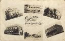
| Date: | |
|---|---|
| Description: | Photographic collage of six views of Black River Falls, featuring the Grade School, High School, Bank, Main Street, a commercial business block and the da... |

| Date: | 06 12 1929 |
|---|---|
| Description: | This manuscript blueprint shows buildings with the names of their owners, tabernacle, location "where Strang found plates" and "house where Strang died," a... |
If you didn't find the material you searched for, our Library Reference Staff can help.
Call our reference desk at 608-264-6535 or email us at: