 Filter: Categories of Wisconsin Historical Images
Filter: Subject of School buildings
Filter: Subject of aerial photographs
Filter: Categories of Wisconsin Historical Images
Filter: Subject of School buildings
Filter: Subject of aerial photographs
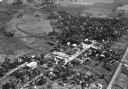
| Date: | 1965 |
|---|---|
| Description: | Aerial view of Iola, Wisconsin looking west. Located in the lower left corner is an elementary school. |
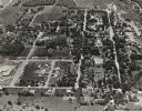
| Date: | 11 1928 |
|---|---|
| Description: | Aerial view of Oregon, including the central business disctrict, residential areas, schools, and the surrounding countryside. |

| Date: | 1957 |
|---|---|
| Description: | An aerial view of Edgewood College and Schools. |

| Date: | 1957 |
|---|---|
| Description: | An aerial view of Edgewood College and Schools. |

| Date: | 1930 |
|---|---|
| Description: | Aerial view of near west side, including West High School, the Forest Products Laboratory, Lake Mendota, and Picnic Point. |
| Date: | 1934 |
|---|---|
| Description: | Aerial view of the play area for Roosevelt School. |
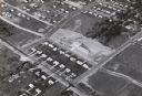
| Date: | 1958 |
|---|---|
| Description: | Aerial view of Orchard Ridge School, at 5602 Russett Road. |

| Date: | 02 06 1948 |
|---|---|
| Description: | Looking east along Regent Street with snow on the ground. Visible are Lake Wingra, Monona Bay, railroad causeway across Monona, Lake Mendota, Hoyt Park, We... |
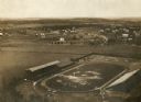
| Date: | 1909 |
|---|---|
| Description: | Aerial view looking north over Camp Randall stadium towards University Heights. In the right-center area of the photograph, the Wayland J. Chase residence,... |

| Date: | 03 06 1948 |
|---|---|
| Description: | Aerial view of High School, in the upper half of the image, with fields, trees, and roadways surrounding it. In the lower half is a residential neighborho... |

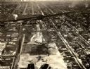
| Date: | |
|---|---|
| Description: | Aerial view of the Capitol Square, with Capitol Park and part of the Wisconsin State Capitol. Manchester's is on the corner of Mifflin Street at Wisconsin ... |
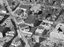
| Date: | |
|---|---|
| Description: | Aerial view of Madison, including Yost's, State Street, The Orpheum Theatre, Hills, the Madison Public Library, block 64 parking, East Johnson Street, and ... |

| Date: | 1945 |
|---|---|
| Description: | An aerial view, looking northeast, that includes the intersection at Atwood and Fair Oaks Avenues. Elmside Circle Park is on the bottom left. The Madison-K... |

| Date: | 1968 |
|---|---|
| Description: | Aerial view looking southwest, with Lake Mendota at right and East Gorham Street running from the bottom left corner. Lincoln School is in the foreground, ... |

| Date: | 1968 |
|---|---|
| Description: | Air view of the University of Wisconsin-Madison campus looking north to Lake Mendota. Picnic Point, currently part of the Lakeshore Nature Preserve, and Ca... |

| Date: | 1967 |
|---|---|
| Description: | Air view looking north toward Lake Mendota. The intersection of West Washington Ave. and S. Park Street is at bottom center. The Triangle Redevelopment Pro... |

| Date: | |
|---|---|
| Description: | Aerial view of the Greenbush neighborhood in winter partially demolished for the Triangle Redevelopment Project. Monona Bay and Brittingham park are at rig... |
If you didn't find the material you searched for, our Library Reference Staff can help.
Call our reference desk at 608-264-6535 or email us at: