Filter: Categories of Wisconsin Historical Images
Filter: Subject of School buildings
Filter: County of Waukesha
Filter: Subject of human settlements
Filter: Categories of Wisconsin Historical Images
Filter: Subject of School buildings
Filter: County of Waukesha
Filter: Subject of human settlements

| Date: | 1874 |
|---|---|
| Description: | Bird's-eye view of Waukesha, looking southwest, with insets of State Industrial School, Court House, and Fountain Spring House. |
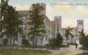
| Date: | 1905 |
|---|---|
| Description: | View of St. John's Military Academy. Caption reads: "St. John's Military Academy, Delafield, Wis.". |

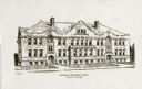
| Date: | 1890 |
|---|---|
| Description: | View of Carroll College, with groups of men and women standing outside of the building. |
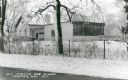
| Date: | 1971 |
|---|---|
| Description: | View from road across fence towards the Old Center Oak School in Monches. Snow is on the ground. Caption reads: "Old Center Oak School, Monches, Wis." |
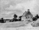
| Date: | 1851 |
|---|---|
| Description: | School and church, from a drawing by Johann B. Wengler, an Austrian traveller in this country. |
| Date: | 1933 |
|---|---|
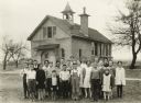
| Description: | Students standing in front of Hillcrest School, a one-room school in Waukesha County. |
| Date: | 1924 |
|---|---|
| Description: | View from the road facing the front and side of the public school built in 1905. A swing set is to the left of the school building. The building has an arc... |

| Date: | 1891 |
|---|---|
| Description: | This late 19th century map shows the lake region around Oconomowoc in Waukesha County and eastern Jefferson County, Wisconsin. The township and range grid,... |

| Date: | 1876 |
|---|---|
| Description: | This late 19th century map by Increase Lapham shows the lake region around Oconomowoc in Waukesha County and eastern Jefferson County, Wisconsin. Cities an... |

| Date: | 1887 |
|---|---|
| Description: | This late 19th century map shows the lake region around Oconomowoc in Waukesha County and eastern Jefferson County, Wisconsin. Cities and villages, roads, ... |

| Date: | 1930 |
|---|---|
| Description: | This map of Waukesha County, Wisconsin, from the 1930s shows the township and range grid, towns, sections, cities and villages, highways and roads, railroa... |

| Date: | 1911 |
|---|---|
| Description: | This 1911 map from the U.S. Post Office Dept. shows rural delivery routes, active and discontinued post offices, selected rural landowners and houses, chur... |

| Date: | 1933 |
|---|---|
| Description: | Roger Baird, 11 years old and a student at Hillcrest School, District No. 6, Towns of Waukesha, Pewaukee, Brookfield and New Berlin, poses on the arched fr... |

| Date: | 1933 |
|---|---|
| Description: | Felix Liburdi, 17 years old, poses in front of the arched front porch of the Hillcrest School, District No. 6, Towns of Waukesha, Pewaukee, Brookfield and ... |

| Date: | 1920 |
|---|---|
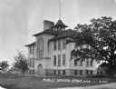
| Description: | Photographic postcard view of the public school building. Caption reads: "Public School — Eagle, Wis." |

| Date: | 1965 |
|---|---|
| Description: | This map shows wards, schools and public buildings, and polling places. The map includes a street index. Lac La Belle, Fowler Lake, and Oconomowoc Lake are... |
| Date: | |
|---|---|
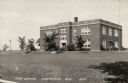
| Description: | View across lawn towards a two-story brick high school. Young trees and shrubs have been planted on the grounds. Caption reads: "High School, Hartland, Wis... |
If you didn't find the material you searched for, our Library Reference Staff can help.
Call our reference desk at 608-264-6535 or email us at: