 Filter: Categories of Wisconsin Historical Images
Filter: Subject of School buildings
Filter: Community of Milwaukee
Filter: Categories of Wisconsin Historical Images
Filter: Subject of School buildings
Filter: Community of Milwaukee
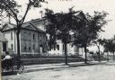
| Date: | 1890 |
|---|---|
| Description: | Exterior of Walter Allen School, with a woman in a carriage parked in front. The Walter Allen School was an elementary school located at 1657 South Third S... |
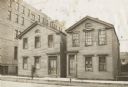
| Date: | 1920 |
|---|---|
| Description: | First location of the high school at 301-303 Fifth Street. Consists of two house-sized buildings, with the entrances close to each other. Sign on front of ... |

| Date: | 1910 |
|---|---|
| Description: | The entrance on the left has a small domed tower, and on the right is a chimney. Caption reads: "South Side High School, Milwaukee, Wis." |

| Date: | |
|---|---|
| Description: | View of men on field during football game. Possibly taken in Milwaukee, Wisconsin. In the background a crowd is watching on stands in front of a large bric... |

| Date: | 1938 |
|---|---|
| Description: | Children standing in line, boarding an International D-300 bus near what appears to be a school building. This bus was equipped with 165" Hicks body. |

| Date: | 1938 |
|---|---|
| Description: | Children standing in line, boarding an International D-300 bus near what appears to be a school buiding. This bus was equipped with 165" Hicks body. |
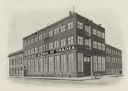
| Date: | 1906 |
|---|---|
| Description: | An exterior view of the Milwaukee School of Trades. |

| Date: | 1901 |
|---|---|
| Description: | Milwaukee Public school, Sixth district School no. 2, Fifth grade class. teacher Miss H. Kather, Patrick Shaunnessy Principal. Boys: Emil Dankert, Charles ... |

| Date: | 1863 |
|---|---|
| Description: | Includes index to public buildings, churches, schools. Inset: Glidden & Lockwood’s addition. Gives names of some property owners. |

| Date: | 05 1958 |
|---|---|
| Description: | Photocopy of a map created by the City of Milwaukee Master Plan Program City Planning Division in May of 1958 representing 1870 "THE CENTRAL AREA OF THE CI... |

| Date: | 1857 |
|---|---|
| Description: | This map shows lot and block numbers, wards, roads, railroads, some landowners’ names, and selected buildings. The map includes an inset map of Glidden & L... |

| Date: | 1857 |
|---|---|
| Description: | This map shows lot and block numbers, wards, roads, railroads, some landowners’ names, and selected buildings. Lake Michigan, the Milwaukee River, and Glid... |

| Date: | 1857 |
|---|---|
| Description: | This map shows lot and block numbers, wards, roads, railroads, some landowners’ names, and selected buildings. Lake Michigan, the Milwaukee River, and Glid... |

| Date: | 1910 |
|---|---|
| Description: | A Sanborn insurance map of Milwaukee, including the shore of Lake Michigan. |

| Date: | 11 15 1967 |
|---|---|
| Description: | A young man in a Milwaukee N.A.A.C.P. Youth Council t-shirt is standing and talking to a group of children. Caption reads: "Richard E. Green, 22, of 3233 N... |
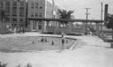
| Date: | 1938 |
|---|---|
| Description: | A view, looking south, at the intersection of West Mt. Vernon Avenue and North 65th Street. In the foreground is a shallow pool where children are playing,... |

| Date: | 06 08 1989 |
|---|---|
| Description: | A man is smiling and leaning against a school desk. Caption reads: "Brother Norbert Karpfinger will be leaving Milwaukee." |

| Date: | 10 01 1977 |
|---|---|
| Description: | Several African-American teenagers are standing outside a building, some wearing coats and some under umbrellas. A sign reads: "Fight for the Right." Capti... |

| Date: | 11 09 1960 |
|---|---|
| Description: | A uniformed police officer is sitting in a folding chair and moving pieces on a chessboard. Caption reads: "On duty Tuesday at the voting place in t... |
If you didn't find the material you searched for, our Library Reference Staff can help.
Call our reference desk at 608-264-6535 or email us at: