 Filter: Categories of Wisconsin Historical Images
Filter: Subject of School buildings
Filter: Creator Name of Standard Map Company
Filter: Categories of Wisconsin Historical Images
Filter: Subject of School buildings
Filter: Creator Name of Standard Map Company

| Date: | 1930 |
|---|---|
| Description: | This map of Waukesha County, Wisconsin, from the 1930s shows the township and range grid, towns, sections, cities and villages, highways and roads, railroa... |
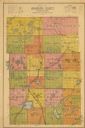
| Date: | 1938 |
|---|---|
| Description: | Map shows roads, townships and sections, railroads, water, and schools. |
If you didn't find the material you searched for, our Library Reference Staff can help.
Call our reference desk at 608-264-6535 or email us at: