 Filter: Categories of Wisconsin Historical Images
Filter: Subject of Sawmills
Filter: Categories of Wisconsin Historical Images
Filter: Subject of Sawmills
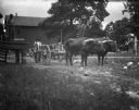
| Date: | 05 1902 |
|---|---|
| Description: | Two teams of yoked oxen pulling carts used to transport logs to, and lumber from sawmills. There is a large, wood frame two-story building in the backgroun... |
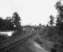
| Date: | 05 1902 |
|---|---|
| Description: | Alexander Krueger and Ernst Goetsch standing along a railroad track leading to a sawmill. The mill stais at the end of the tracks, which is lined with tree... |
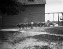
| Date: | 05 1902 |
|---|---|
| Description: | View across yard towards six oxen pulling a lumber wagon along a road near a sawmill. A man is standing beside the oxen holding a long whip over his should... |

| Date: | 1910 |
|---|---|
| Description: | Photographic postcard of a group of workers, horses, and a dog posing at railroad siding at C.W. Begg's Mill. Caption reads: "C.W. Begg's Mill at Siding, C... |
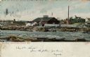
| Date: | 1909 |
|---|---|
| Description: | Colorized view of Big Mill, a lumber sawmill on the Chippewa river, next to a churning rapids. In the foreground are loose logs, whitewater, river boulders... |

| Date: | |
|---|---|
| Description: | View towards three men posing standing near a steam-powered open saw mill next to piles of logs. |

| Date: | |
|---|---|
| Description: | Group portrait of men, women, and a child posing standing next to a steam-powered open saw mill next to piles of logs. |

| Date: | |
|---|---|
| Description: | Group portrait of a group of men sitting near an open steam-powered saw mill. |

| Date: | |
|---|---|
| Description: | View towards a group of men posing standing by a pile of logs on snow-covered ground in front of a steam-powered saw mill. |

| Date: | 1876 |
|---|---|
| Description: | This map is ink on tracing cloth and shows the Black River, French Slough, Little French Slough, the southern portion of North La Crosse, the Milwaukee & S... |

| Date: | 06 1923 |
|---|---|
| Description: | Sanborn map of Ashland, which includes Chequamegon Bay. |

| Date: | 1891 |
|---|---|
| Description: | This map shows vacant Southwick & Sellers lands, settlers' houses, Goodland Co. land, schools, churches, saw mills, roads, and railroads. A key in the uppe... |

| Date: | 1909 |
|---|---|
| Description: | This map shows vacant Wisconsin Central Ry. lands, settlers houses, lands sold by Wisconsin Central Ry., schools, churches, saw mills, and roads; also show... |

| Date: | 1909 |
|---|---|
| Description: | This map covers Iron and Price Counties and portions of Sawyer and Oneida Counties. The map shows vacant and sold Wis. Central Ry. land, settlers houses, s... |

| Date: | 1890 |
|---|---|
| Description: | View from hill of the McKenna Sawmill, surrounded by stacks of lumber. |

| Date: | 1890 |
|---|---|
| Description: | View of the McKenna Sawmill. Workers are posing in front. |

| Date: | 1923 |
|---|---|
| Description: | This blue line print map shows townships, landownership, roads, residences, churches, schools, town halls, saw mills, and cheese factories. Includes red ma... |

| Date: | |
|---|---|
| Description: | View towards men standing and sitting near a wooden structure, perhaps a sawmill. |

| Date: | |
|---|---|
| Description: | Elevated view of a group of employees assembled in front of a sawmill. |

| Date: | 1900 |
|---|---|
| Description: | This photostat of a manuscript map originally drawn in 1829 shows landownership, buildings, including Fort Howard and U.S. sawmill, swamps, public barns an... |
If you didn't find the material you searched for, our Library Reference Staff can help.
Call our reference desk at 608-264-6535 or email us at: