 Filter: Categories of Wisconsin Historical Images
Filter: Subject of Sawmills
Filter: Categories of Wisconsin Historical Images
Filter: Subject of Sawmills
| Date: | |
|---|---|
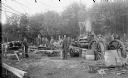
| Description: | Men posed using a steam-powered open-air saw, probably using a steam tractor for power. |

| Date: | 1914 |
|---|---|
| Description: | This map is a photostat copy from the original 1829 map in the War Department. The map shows location of Fort Howard, lots, land claims of Jacques Porlier ... |

| Date: | |
|---|---|
| Description: | Large group of men posed standing in front of a sawmill. Three men are posed standing in a wagon pulled by a team of two horses wearing fly-nets. One man w... |
| Date: | 01 1928 |
|---|---|
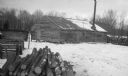
| Description: | The sawmill at Newport in winter, with logs and lumber stacked nearby. |
| Date: | 1925 |
|---|---|
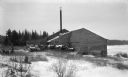
| Description: | Logs are stacked beside a sawmill in a winter landscape. The mill has a tall smokestack and stands near the shore. |

| Date: | 1909 |
|---|---|
| Description: | A map of Langlade County, Wisconsin that shows townships and ranges, towns, cities and villages, wagon roads, churches, schools, sawmills, town halls, chee... |

| Date: | 1915 |
|---|---|
| Description: | This 1915 map of Lincoln County, Wisconsin, shows the township and range grid, towns, cities and villages, lakes and streams, residences, churches, school ... |

| Date: | 1896 |
|---|---|
| Description: | This 1896 map shows the township and range system, sections, cities and villages, railroads, vacant land and land sold by the Wisconsin Central Railroad, s... |

| Date: | 1898 |
|---|---|
| Description: | This 1898 map shows the township and range system, sections, cities and villages, railroads, vacant land, land sold by the Wisconsin Central Railroad, incl... |

| Date: | 1888 |
|---|---|
| Description: | This late 19th century map of Price County, Wisconsin, shows landownership and waterfront acreages, the township and range system, towns, cities and villag... |

| Date: | 1914 |
|---|---|
| Description: | This 1914 map of Price County, Wisconsin, shows land for sale by the Good Land Company and Dewitt van Ostrand of Phillips. Also shown are the township and ... |

| Date: | 1896 |
|---|---|
| Description: | This 1896 map shows the township and range system, sections, cities and villages, railroads, roads, vacant land and land sold by the Wisconsin Central Rail... |

| Date: | 1896 |
|---|---|
| Description: | This 1898 map shows the township and range system, sections, cities and villages, railroads, roads, vacant land and land sold by the Wisconsin Central Rail... |

| Date: | 1900 |
|---|---|
| Description: | This 1900 map shows the township and range system, sections, cities and villages, railroads, roads, vacant land and land sold by the Wisconsin Central Rail... |

| Date: | 1871 |
|---|---|
| Description: | This map of Barron County, Wisconsin, shows the township and range grid, towns, sections, cities and villages, post offices, dwellings, schools, roads, swa... |

| Date: | 1887 |
|---|---|
| Description: | This 1896 map shows the township and range system, sections, cities and villages, railroads, roads, vacant land and land sold by the Wisconsin Central Rail... |

| Date: | 1898 |
|---|---|
| Description: | This 1898 map shows the township and range system, sections, cities and villages, railroads, roads, vacant land and land sold by the Wisconsin Central Rail... |

| Date: | 1909 |
|---|---|
| Description: | This 1909 map of Taylor County, Wisconsin, shows the township and range grid, towns, sections, cities and villages, settlers houses, schools, churches, saw... |

| Date: | |
|---|---|
| Description: | This map of Taylor County, Wisconsin, shows soil types, the township and range grid, sections, settlers houses, schools, churches, saw mills, tanneries, ro... |

| Date: | 1908 |
|---|---|
| Description: | This 1908 map shows the town and range grid, sections, cities and villages, acreages, settlers, schools, wagon roads, railroads, saw mills, and lakes, stre... |
If you didn't find the material you searched for, our Library Reference Staff can help.
Call our reference desk at 608-264-6535 or email us at: