 Filter: Categories of Wisconsin Historical Images
Filter: Subject of Sawmills
Filter: Year of 1900-1999
Filter: Subject of indian reservations
Filter: Categories of Wisconsin Historical Images
Filter: Subject of Sawmills
Filter: Year of 1900-1999
Filter: Subject of indian reservations

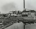
| Date: | 1910 |
|---|---|
| Description: | Sawmill on a Menominee Indian reservation, with logs floating in the water in the foreground. Caption reads: "Menominee Indian Mills." |
| Date: | 1950 |
|---|---|
| Description: | A sawmill run on the Menominee Indian Reservation. |

| Date: | 1900 |
|---|---|
| Description: | This 1900 map shows the township and range system, sections, cities and villages, railroads, roads, vacant land and land sold by the Wisconsin Central Rail... |

| Date: | 1909 |
|---|---|
| Description: | This map shows vacant Wisconsin Central Ry. lands, settlers houses, lands sold by Wisconsin Central Ry., schools, churches, saw mills, and roads; also show... |
If you didn't find the material you searched for, our Library Reference Staff can help.
Call our reference desk at 608-264-6535 or email us at: