Filter: Categories of Wisconsin Historical Images
Filter: Subject of Sawmills
Filter: Year of 1800-1899
Filter: Year of 1890-1899
Filter: Categories of Wisconsin Historical Images
Filter: Subject of Sawmills
Filter: Year of 1800-1899
Filter: Year of 1890-1899
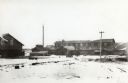
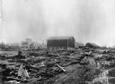
| Date: | 1890 |
|---|---|
| Description: | Small town completely dependent on the sawmill. When the sawmill closed down, the town disappeared. |
| Date: | 1898 |
|---|---|
| Description: | The Nekoosa-Edwards Paper company. Established about 1896 by John Edwards. |
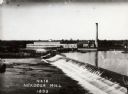
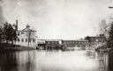
| Date: | 1898 |
|---|---|
| Description: | A view of the Nekoosa-Edwards Paper Company mill. Established about 1896 by John Edwards. Caption reads: "Nekoosa Mill". |
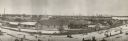
| Date: | 1896 |
|---|---|
| Description: | A view of Nekoosa-Edwards Paper Company mills. Established about 1896 by John Edwards. |
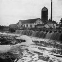
| Date: | 1890 |
|---|---|
| Description: | View of the Peshtigo Company sawmill including the old wooden dam in the foreground. There are logs in the water on the left. |
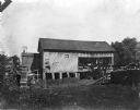
| Date: | 1890 |
|---|---|
| Description: | A view of Rudolph Herrling's sawmill and log yard in front of the Herling farm. |
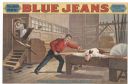
| Date: | 1890 |
|---|---|
| Description: | Color lithograph poster. At top, the main banner reads "Blue Jeans" with insert at left "Will Never Wear Out" and another at right "By Joseph Arthur/The Au... |
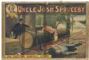
| Date: | 1890 |
|---|---|
| Description: | Color lithograph poster. Top banner "Uncle Josh Spruceby" with insert left containing picture of Uncle Josh. The image depicts a scene from the play with a... |

| Date: | 1896 |
|---|---|
| Description: | This 1896 map shows the township and range system, sections, cities and villages, railroads, vacant land and land sold by the Wisconsin Central Railroad, s... |

| Date: | 1898 |
|---|---|
| Description: | This 1898 map shows the township and range system, sections, cities and villages, railroads, vacant land, land sold by the Wisconsin Central Railroad, incl... |

| Date: | 1896 |
|---|---|
| Description: | This 1896 map shows the township and range system, sections, cities and villages, railroads, roads, vacant land and land sold by the Wisconsin Central Rail... |

| Date: | 1896 |
|---|---|
| Description: | This 1898 map shows the township and range system, sections, cities and villages, railroads, roads, vacant land and land sold by the Wisconsin Central Rail... |

| Date: | 1898 |
|---|---|
| Description: | This 1898 map shows the township and range system, sections, cities and villages, railroads, roads, vacant land and land sold by the Wisconsin Central Rail... |

| Date: | 1898 |
|---|---|
| Description: | This 1898 map of Ashland County, Wisconsin, shows the township and range grid, towns, sections, cities and villages, landownership, roads, railroads, swamp... |

| Date: | 1890 |
|---|---|
| Description: | Shows vacant state land, government land, townships, and selected farms, camps, saw mills, etc. in Vilas and Oneida Counties, and part of Iron County. "For... |

| Date: | 1892 |
|---|---|
| Description: | Map shows farms, schools, saw mills, townships, railroads, and roads. Counties are labelled and are outlined in yellow and pink. On the upper right and le... |
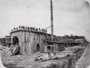
| Date: | 1890 |
|---|---|
| Description: | Men pose on top of and in front of the Spaulding, Van Hoosier & Company Sawmill. |
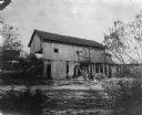
| Date: | 1890 |
|---|---|
| Description: | Herling Saw Mill and Dam Southeast elevation. |
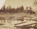
| Date: | 1890 |
|---|---|
| Description: | 90,000 feet of pine logs floating in the storage/sorting pond at the Arpin Lumber Company sawmill. The sawmill and other buildings are in the background. O... |
If you didn't find the material you searched for, our Library Reference Staff can help.
Call our reference desk at 608-264-6535 or email us at: