 Filter: Categories of Wisconsin Historical Images
Filter: Subject of Sawmills
Filter: Year of 1800-1899
Filter: Year of 1880-1889
Filter: Categories of Wisconsin Historical Images
Filter: Subject of Sawmills
Filter: Year of 1800-1899
Filter: Year of 1880-1889

| Date: | 1881 |
|---|---|
| Description: | Bird's-eye map of Marinette, with insets. |

| Date: | 1886 |
|---|---|
| Description: | Bird's-eye view of Ashland, on the shores of Lake Superior, with insets of The Apostle Islands Chequamagon Bay & Ashland, and Distances from Ashland. |

| Date: | 1886 |
|---|---|
| Description: | Bird's-eye map of Washburn on Lake Superior. There is an inset of Washburn, Chequamagon and the Apostle Islands. |
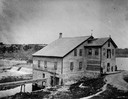
| Date: | 1885 |
|---|---|
| Description: | View of the Rockdale mill, a grist and sawmill built in 1847 by Thomas and Nathan Van Horn. A group of people are standing on a sidewalk or loading dock on... |
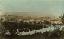
| Date: | 1880 |
|---|---|
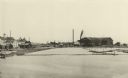
| Description: | View from high bank across the river of the Ingram and Pinkum sawmill (left), Ingram and Kennedy mill (right), later incorporated as the Empire Lumber Co. ... |

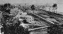
| Date: | 1880 |
|---|---|
| Description: | Clark's Saw and Planing Mill in the right foreground which is now the site of the electric plant. Behind Clark's is Plummers Mill where the Vocational Scho... |
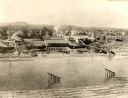
| Date: | 1885 |
|---|---|
| Description: | Elevated view of Shell Lake looking towards the sawmills. |
| Date: | 1880 |
|---|---|
| Description: | The sawmill of Gilbert E. Porter and Delos R. Moon was located on the Chippewa River approximately three miles southwest of the city of Eau Claire. In 1873... |
| Date: | 1887 |
|---|---|
| Description: | A view at the mouth of the Menominee River showing Ludington Wells and Van Schaick's mills. |

| Date: | 1887 |
|---|---|
| Description: | The Ramsay & Jones Mill with logs in the water in the foreground. |

| Date: | 1888 |
|---|---|
| Description: | This late 19th century map of Price County, Wisconsin, shows landownership and waterfront acreages, the township and range system, towns, cities and villag... |

| Date: | 1887 |
|---|---|
| Description: | This 1896 map shows the township and range system, sections, cities and villages, railroads, roads, vacant land and land sold by the Wisconsin Central Rail... |
| Date: | 1888 |
|---|---|
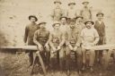
| Description: | Ed McDill's sawmill crew. Left to right: George Dickerman, George Norton, Charles Norton, Jesse Dickerman and, in a derby, Ed McDill, the owner. The boys a... |

| Date: | 1886 |
|---|---|
| Description: | This map has relief shown by hachures and includes a list of plats in order of date of record, laws which vacate plats, plats not shown as upon the county ... |

| Date: | 1888 |
|---|---|
| Description: | This map has relief shown by hachures and features inset maps of a plat of E.D. Clinton and Blackwell’s add’n to the City of La Crosse. Wards (1-10) shaded... |
If you didn't find the material you searched for, our Library Reference Staff can help.
Call our reference desk at 608-264-6535 or email us at:

