 Filter: Categories of Wisconsin Historical Images
Filter: Subject of Sawmills
Filter: Year of 1800-1899
Filter: Subject of rivers
Filter: Categories of Wisconsin Historical Images
Filter: Subject of Sawmills
Filter: Year of 1800-1899
Filter: Subject of rivers
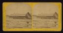
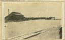
| Date: | 1867 |
|---|---|
| Description: | Mill dam and sash factory. "The Northwester Gateway. Excursion to Lake Superior, June 1867. Photographed and Published by J. Carbutt, 131 Lake St., Chicago... |

| Date: | 1881 |
|---|---|
| Description: | Bird's-eye map of Marinette, with insets. |

| Date: | 1850 |
|---|---|
| Description: | Painting depicting Chippewa Falls and the first sawmill on the Chippewa River, built by Jean Brunet. The residence of H.S. Allen, one of the owners of the... |

| Date: | 1867 |
|---|---|
| Description: | Birds-eye drawing of Appleton, Outagamie Co., depicting street names and street layout, houses, the Fox River, the court house, jail, school houses, Lawren... |
| Date: | 1875 |
|---|---|
| Description: | View, through a cornfield, of people, a store, a sawmill and wagons. Moscow was platted in 1850 by an Englishman, Chauncy Smith, who dammed the Bluemound ... |
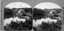
| Date: | 1875 |
|---|---|
| Description: | View of a bridge, dam and mill. Moscow was platted in 1850 by an Englishman, Chauncy Smith, who dammed the Bluemound branch of the Pecatonica River to run ... |
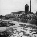
| Date: | 1868 |
|---|---|
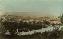
| Description: | View of the Baraboo River and surrounding structures. |
| Date: | 1880 |
|---|---|
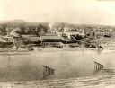
| Description: | View from high bank across the river of the Ingram and Pinkum sawmill (left), Ingram and Kennedy mill (right), later incorporated as the Empire Lumber Co. ... |

| Date: | 1880 |
|---|---|
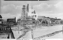
| Description: | Clark's Saw and Planing Mill in the right foreground which is now the site of the electric plant. Behind Clark's is Plummers Mill where the Vocational Scho... |
| Date: | 1880 |
|---|---|
| Description: | The sawmill of Gilbert E. Porter and Delos R. Moon was located on the Chippewa River approximately three miles southwest of the city of Eau Claire. In 1873... |
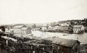
| Date: | 1856 |
|---|---|
| Description: | View across water toward the sawmill and various outbuildings located on the Oconto River. Steam is rising from a large pipe over over the main building, a... |
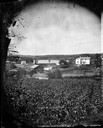
| Date: | 1856 |
|---|---|
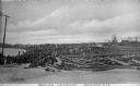
| Description: | Large piles of logs waiting to be processed into lumber sit next to the Oconto River. In the background stand what appear to be piles of cut lumber. Captio... |
| Date: | 07 30 1865 |
|---|---|
| Description: | An exterior view across water of Robert Stephenson & Company Mill, which was a steam mill. |
| Date: | 1890 |
|---|---|
| Description: | View of the Peshtigo Company sawmill including the old wooden dam in the foreground. There are logs in the water on the left. |
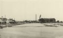
| Date: | 1887 |
|---|---|
| Description: | A view at the mouth of the Menominee River showing Ludington Wells and Van Schaick's mills. |

| Date: | 1896 |
|---|---|
| Description: | This 1896 map shows the township and range system, sections, cities and villages, railroads, vacant land and land sold by the Wisconsin Central Railroad, s... |

| Date: | 1888 |
|---|---|
| Description: | This late 19th century map of Price County, Wisconsin, shows landownership and waterfront acreages, the township and range system, towns, cities and villag... |

| Date: | 1896 |
|---|---|
| Description: | This 1896 map shows the township and range system, sections, cities and villages, railroads, roads, vacant land and land sold by the Wisconsin Central Rail... |

| Date: | 1896 |
|---|---|
| Description: | This 1898 map shows the township and range system, sections, cities and villages, railroads, roads, vacant land and land sold by the Wisconsin Central Rail... |
If you didn't find the material you searched for, our Library Reference Staff can help.
Call our reference desk at 608-264-6535 or email us at:
