 Filter: Categories of Wisconsin Historical Images
Filter: Subject of Sawmills
Filter: Year of 1800-1899
Filter: Subject of food industry and trade
Filter: Categories of Wisconsin Historical Images
Filter: Subject of Sawmills
Filter: Year of 1800-1899
Filter: Subject of food industry and trade
| Date: | 1875 |
|---|---|
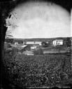
| Description: | View, through a cornfield, of people, a store, a sawmill and wagons. Moscow was platted in 1850 by an Englishman, Chauncy Smith, who dammed the Bluemound ... |
| Date: | 1868 |
|---|---|
| Description: | View of the Baraboo River and surrounding structures. |
| Date: | 1885 |
|---|---|
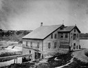
| Description: | View of the Rockdale mill, a grist and sawmill built in 1847 by Thomas and Nathan Van Horn. A group of people are standing on a sidewalk or loading dock on... |
| Date: | 1851 |
|---|---|
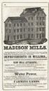
| Description: | Engraving of the five-story tall mill erected at the outlet of the Yahara Creek by Leonard J. Farwell. This engraving appears in Statistics of Dane County,... |

| Date: | 1871 |
|---|---|
| Description: | This map of Barron County, Wisconsin, shows the township and range grid, towns, sections, cities and villages, post offices, dwellings, schools, roads, swa... |

| Date: | 1870 |
|---|---|
| Description: | This 1870 map of Brown County, Wisconsin, shows the township and range grid, towns, sections, cities, villages and post offices, land ownership, roads, rai... |

| Date: | 1842 |
|---|---|
| Description: | Relief shown by hachures. Shows furnaces, saw mills, houses, roads, grist mills, entries, reservations, and diggings. "Compiled by order of the Board of C... |

| Date: | 1859 |
|---|---|
| Description: | This map show plats including plat names, plat numbers, and some lot owner's names. Relief is shown by hachures. The map includes line drawings of Juneau B... |

| Date: | 1886 |
|---|---|
| Description: | This map has relief shown by hachures and includes a list of plats in order of date of record, laws which vacate plats, plats not shown as upon the county ... |

| Date: | 1855 |
|---|---|
| Description: | This map is ink, pen, and watercolor on paper and shows plat of the town, local streets, lots by number, U.S. subdivisions in red lines, Mineral Point Rail... |

| Date: | 1875 |
|---|---|
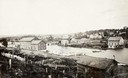
| Description: | Elevated view of several buildings, with bridge and railroad tracks, and the Fox River. In the foreground on the right is the Commercial House, with three ... |
If you didn't find the material you searched for, our Library Reference Staff can help.
Call our reference desk at 608-264-6535 or email us at:
