Filter: Categories of Wisconsin Historical Images
Filter: Subject of Sawmills
Filter: Subject of wisconsin river (wis.)
Filter: Categories of Wisconsin Historical Images
Filter: Subject of Sawmills
Filter: Subject of wisconsin river (wis.)
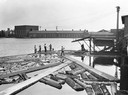
| Date: | 1930 |
|---|---|
| Description: | Workers push logs floating in the Wisconsin River into alignment to enter a building for processing. |

| Date: | 05 02 1964 |
|---|---|
| Description: | Sitting on the school lawn, students draw Highway 51, Marathon Mill, Rib mountain and the Wisconsin River. |

| Date: | 1890 |
|---|---|
| Description: | Shows vacant state land, government land, townships, and selected farms, camps, saw mills, etc. in Vilas and Oneida Counties, and part of Iron County. "For... |

| Date: | 1901 |
|---|---|
| Description: | A Sanborn map of Tomahawk featuring the Bay Mill Company's lumber yard. |
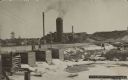
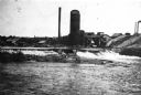
| Date: | 1909 |
|---|---|
| Description: | Text on front reads: "Brooks & Ross Sawmill & Dam, Schofield, Wis. 1909." The dam and millpond with the sawmill behind it. There are multiple buildings wit... |
If you didn't find the material you searched for, our Library Reference Staff can help.
Call our reference desk at 608-264-6535 or email us at: