 Filter: Categories of Wisconsin Historical Images
Filter: Subject of Sawmills
Filter: Subject of water
Filter: Categories of Wisconsin Historical Images
Filter: Subject of Sawmills
Filter: Subject of water
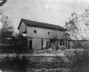
| Date: | 1890 |
|---|---|
| Description: | Herling Saw Mill and Dam Southeast elevation. |

| Date: | 1900 |
|---|---|
| Description: | Man standing in front of a sawmill waterway. In the background on the opposite shoreline are the sawmill buildings. |
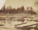
| Date: | 1890 |
|---|---|
| Description: | 90,000 feet of pine logs floating in the storage/sorting pond at the Arpin Lumber Company sawmill. The sawmill and other buildings are in the background. O... |

| Date: | |
|---|---|
| Description: | A hand-drawn map of Camp Curtis which was prepared for Colonel R. McMurphy. |

| Date: | 1859 |
|---|---|
| Description: | This map show plats including plat names, plat numbers, and some lot owner's names. Relief is shown by hachures. The map includes line drawings of Juneau B... |

| Date: | 1886 |
|---|---|
| Description: | This map has relief shown by hachures and includes a list of plats in order of date of record, laws which vacate plats, plats not shown as upon the county ... |

| Date: | 1888 |
|---|---|
| Description: | This map has relief shown by hachures and features inset maps of a plat of E.D. Clinton and Blackwell’s add’n to the City of La Crosse. Wards (1-10) shaded... |
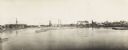
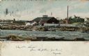
| Date: | 1900 |
|---|---|
| Description: | Semi-panoramic view of a river town showing extensive sawmill operations. |

| Date: | 1857 |
|---|---|
| Description: | This map shows section corners, quarter section corners, foundry, steam saw mill, steam grist mill, planning mill, court house, baptist church, congregatio... |

| Date: | 09 1891 |
|---|---|
| Description: | Sanborn map of Hurley, featuring the Village of Gile and the Montreal River Lumber Company. |

| Date: | 1898 |
|---|---|
| Description: | Sanborn map of Hurley featuring the Village of Gile. |

| Date: | 1870 |
|---|---|
| Description: | This map is ink and color on tracing cloth and shows Iron Ridge, the hotel and saw mill at Iron Ridge Village, Milwaukee & St. Paul Railway, plank road, an... |

| Date: | 1855 |
|---|---|
| Description: | This map is ink, pen, and watercolor on paper and shows plat of the town, local streets, lots by number, U.S. subdivisions in red lines, Mineral Point Rail... |
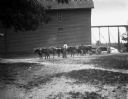
| Date: | 05 1902 |
|---|---|
| Description: | View across yard towards six oxen pulling a lumber wagon along a road near a sawmill. A man is standing beside the oxen holding a long whip over his should... |
| Date: | 1909 |
|---|---|
| Description: | Colorized view of Big Mill, a lumber sawmill on the Chippewa river, next to a churning rapids. In the foreground are loose logs, whitewater, river boulders... |

| Date: | 1876 |
|---|---|
| Description: | This map is ink on tracing cloth and shows the Black River, French Slough, Little French Slough, the southern portion of North La Crosse, the Milwaukee & S... |

| Date: | 06 1923 |
|---|---|
| Description: | Sanborn map of Ashland, which includes Chequamegon Bay. |

| Date: | 1909 |
|---|---|
| Description: | This map shows vacant Wisconsin Central Ry. lands, settlers houses, lands sold by Wisconsin Central Ry., schools, churches, saw mills, and roads; also show... |

| Date: | 1909 |
|---|---|
| Description: | This map covers Iron and Price Counties and portions of Sawyer and Oneida Counties. The map shows vacant and sold Wis. Central Ry. land, settlers houses, s... |

| Date: | 1900 |
|---|---|
| Description: | This photostat map was probably originally created in 1835 and shows in addition to private claims, mills, roads, and trails. Green Bay and the Fox River a... |
If you didn't find the material you searched for, our Library Reference Staff can help.
Call our reference desk at 608-264-6535 or email us at: