 Filter: Categories of Wisconsin Historical Images
Filter: Subject of Sawmills
Filter: Subject of water
Filter: Subject of food industry and trade
Filter: Categories of Wisconsin Historical Images
Filter: Subject of Sawmills
Filter: Subject of water
Filter: Subject of food industry and trade
| Date: | 1875 |
|---|---|
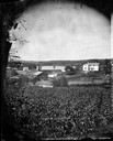
| Description: | View, through a cornfield, of people, a store, a sawmill and wagons. Moscow was platted in 1850 by an Englishman, Chauncy Smith, who dammed the Bluemound ... |
| Date: | 1868 |
|---|---|
| Description: | View of the Baraboo River and surrounding structures. |
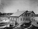
| Date: | 1885 |
|---|---|
| Description: | View of the Rockdale mill, a grist and sawmill built in 1847 by Thomas and Nathan Van Horn. A group of people are standing on a sidewalk or loading dock on... |
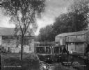
| Date: | |
|---|---|
| Description: | A view of a grist mill and sawmill with a waterfall between them. Caption reads: "Grist and Saw Mill." |

| Date: | 1909 |
|---|---|
| Description: | A map of Langlade County, Wisconsin that shows townships and ranges, towns, cities and villages, wagon roads, churches, schools, sawmills, town halls, chee... |

| Date: | 1915 |
|---|---|
| Description: | This 1915 map of Lincoln County, Wisconsin, shows the township and range grid, towns, cities and villages, lakes and streams, residences, churches, school ... |

| Date: | 1914 |
|---|---|
| Description: | This 1914 map of Price County, Wisconsin, shows land for sale by the Good Land Company and Dewitt van Ostrand of Phillips. Also shown are the township and ... |

| Date: | 1871 |
|---|---|
| Description: | This map of Barron County, Wisconsin, shows the township and range grid, towns, sections, cities and villages, post offices, dwellings, schools, roads, swa... |

| Date: | 1901 |
|---|---|
| Description: | Map shows lakes, rivers, schools, saw mills, post offices, creameries, and churches. Includes significant manuscript annotations showing township divisions... |

| Date: | 1976 |
|---|---|
| Description: | Panel title. Shows railroads, roads, highways, boundaries, dams, public hunting and fishing grounds, cemeteries, forest ranger stations, plant life, and s... |

| Date: | 1859 |
|---|---|
| Description: | This map show plats including plat names, plat numbers, and some lot owner's names. Relief is shown by hachures. The map includes line drawings of Juneau B... |

| Date: | 1886 |
|---|---|
| Description: | This map has relief shown by hachures and includes a list of plats in order of date of record, laws which vacate plats, plats not shown as upon the county ... |

| Date: | 1855 |
|---|---|
| Description: | This map is ink, pen, and watercolor on paper and shows plat of the town, local streets, lots by number, U.S. subdivisions in red lines, Mineral Point Rail... |
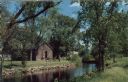
| Date: | |
|---|---|
| Description: | Ektachrome postcard of the blacksmith shop next to a stream. Text on reverse reads: "The Blacksmith Shop was Sylvanus Wade's first venture in Greenbush.... |

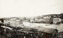
| Date: | 1875 |
|---|---|
| Description: | Elevated view of several buildings, with bridge and railroad tracks, and the Fox River. In the foreground on the right is the Commercial House, with three ... |
If you didn't find the material you searched for, our Library Reference Staff can help.
Call our reference desk at 608-264-6535 or email us at: