 Filter: Categories of Wisconsin Historical Images
Filter: Subject of Sawmills
Filter: Subject of streets
Filter: Creator Name of Unknown
Filter: Categories of Wisconsin Historical Images
Filter: Subject of Sawmills
Filter: Subject of streets
Filter: Creator Name of Unknown
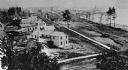
| Date: | 1885 |
|---|---|
| Description: | Elevated view of Shell Lake looking towards the sawmills. |

| Date: | 1876 |
|---|---|
| Description: | This map is ink on tracing cloth and shows the Black River, French Slough, Little French Slough, the southern portion of North La Crosse, the Milwaukee & S... |
If you didn't find the material you searched for, our Library Reference Staff can help.
Call our reference desk at 608-264-6535 or email us at: