 Filter: Categories of Wisconsin Historical Images
Filter: Subject of Sawmills
Filter: Subject of service industries
Filter: Subject of rivers
Filter: Categories of Wisconsin Historical Images
Filter: Subject of Sawmills
Filter: Subject of service industries
Filter: Subject of rivers

| Date: | 1910 |
|---|---|
| Description: | Chippewa Falls from the south side of the river below the falls. Includes the Sheely House Tavern, railway buildings, box cars, a train with five passenger... |
| Date: | |
|---|---|
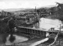
| Description: | Elevated view of the mill, dam, and railroad tracks, and forests surrounding the area. The lumber mill itself, with main building complex and smokestack is... |

| Date: | 1871 |
|---|---|
| Description: | This map of Barron County, Wisconsin, shows the township and range grid, towns, sections, cities and villages, post offices, dwellings, schools, roads, swa... |

| Date: | 1861 |
|---|---|
| Description: | This 1861 map of Columbia County, Wisconsin, shows the township and range grid, towns, sections, cities and villages, railroads, roads, property owners and... |

| Date: | 1901 |
|---|---|
| Description: | Map shows lakes, rivers, schools, saw mills, post offices, creameries, and churches. Includes significant manuscript annotations showing township divisions... |

| Date: | 1902 |
|---|---|
| Description: | This map shows townships, land parcels, schools, rivers, lakes, creameries, churches, cemeteries, roads, post offices, town halls, saw mills, roads and sto... |

| Date: | 1875 |
|---|---|
| Description: | Elevated view of several buildings, with bridge and railroad tracks, and the Fox River. In the foreground on the right is the Commercial House, with three ... |
If you didn't find the material you searched for, our Library Reference Staff can help.
Call our reference desk at 608-264-6535 or email us at: