Filter: Categories of Wisconsin Historical Images
Filter: Subject of Sawmills
Filter: Subject of rivers
Filter: Year of 1900-1999
Filter: Categories of Wisconsin Historical Images
Filter: Subject of Sawmills
Filter: Subject of rivers
Filter: Year of 1900-1999

| Date: | 1905 |
|---|---|
| Description: | Elevated view of Soldiers' Grove with a bridge in the foreground. |

| Date: | 1913 |
|---|---|
| Description: | Bird's-eye map of Superior. "The New Steel Center." |
| Date: | 1948 |
|---|---|
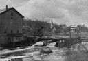
| Description: | Elevated view from shoreline towards the opposite shoreline towards the Buettner mill on the left, and the river with a dam, on the right. In the backgroun... |

| Date: | 1910 |
|---|---|
| Description: | Chippewa Falls from the south side of the river below the falls. Includes the Sheely House Tavern, railway buildings, box cars, a train with five passenger... |
| Date: | 1910 |
|---|---|
| Description: | Distant view of the mill, with a stream leading to it, and a road paralleling the stream on the right. Caption reads: "The Old Mill, Delavan, Wis." |
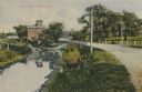
| Date: | 1900 |
|---|---|
| Description: | View up the Eau Claire River from the Dewey Street Bridge. The view shows the dam and linen mill and the site of the lower sawmill (called the "steam mill"... |

| Date: | 1902 |
|---|---|
| Description: | Two panoramic bird's-eye views of the Paine Lumber Company, including the general plant, sawmill, and lumber yards. Heading at the top says: Home of Wiscon... |

| Date: | 1904 |
|---|---|
| Description: | Logs floating down the Chippewa River in front of the "Big Mill". |

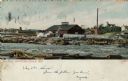
| Date: | 1906 |
|---|---|
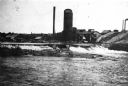
| Description: | View from rocky shoreline of a lumber mill on the banks of the Chippewa River. Smoke is coming out from a smokestack. |

| Date: | 1907 |
|---|---|
| Description: | Elevated view from steep shoreline opposite a lumber mill on the far shore of the Chippewa River, with a bluff rising above it to the right. Boulders are o... |

| Date: | 1914 |
|---|---|
| Description: | This map is a photostat copy from the original 1829 map in the War Department. The map shows location of Fort Howard, lots, land claims of Jacques Porlier ... |

| Date: | 1909 |
|---|---|
| Description: | A map of Langlade County, Wisconsin that shows townships and ranges, towns, cities and villages, wagon roads, churches, schools, sawmills, town halls, chee... |

| Date: | 1908 |
|---|---|
| Description: | This 1908 map shows the town and range grid, sections, cities and villages, acreages, settlers, schools, wagon roads, railroads, saw mills, and lakes, stre... |

| Date: | 1901 |
|---|---|
| Description: | Map shows lakes, rivers, schools, saw mills, post offices, creameries, and churches. Includes significant manuscript annotations showing township divisions... |

| Date: | 1976 |
|---|---|
| Description: | Panel title. Shows railroads, roads, highways, boundaries, dams, public hunting and fishing grounds, cemeteries, forest ranger stations, plant life, and s... |

| Date: | 1900 |
|---|---|
| Description: | Man standing in front of a sawmill waterway. In the background on the opposite shoreline are the sawmill buildings. |
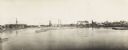
| Date: | 1900 |
|---|---|
| Description: | Semi-panoramic view of a river town showing extensive sawmill operations. |
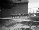
| Date: | 05 1902 |
|---|---|
| Description: | View across yard towards six oxen pulling a lumber wagon along a road near a sawmill. A man is standing beside the oxen holding a long whip over his should... |
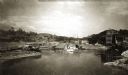
| Date: | 1909 |
|---|---|
| Description: | Colorized view of Big Mill, a lumber sawmill on the Chippewa river, next to a churning rapids. In the foreground are loose logs, whitewater, river boulders... |
If you didn't find the material you searched for, our Library Reference Staff can help.
Call our reference desk at 608-264-6535 or email us at: