 Filter: Categories of Wisconsin Historical Images
Filter: Subject of Sawmills
Filter: Subject of land use
Filter: Subject of cities and towns
Filter: Categories of Wisconsin Historical Images
Filter: Subject of Sawmills
Filter: Subject of land use
Filter: Subject of cities and towns

| Date: | 1850 |
|---|---|
| Description: | Painting depicting Chippewa Falls and the first sawmill on the Chippewa River, built by Jean Brunet. The residence of H.S. Allen, one of the owners of the... |

| Date: | 05 02 1964 |
|---|---|
| Description: | Sitting on the school lawn, students draw Highway 51, Marathon Mill, Rib mountain and the Wisconsin River. |
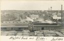
| Date: | 1906 |
|---|---|
| Description: | Elevated view of a sawmill and the distant town in the background. Stacks of logs are in the lumberyard. Along the bottom is a New Year's greeting in Germa... |
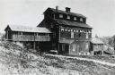
| Date: | |
|---|---|
| Description: | Wooden building with a shed-like extension to a hill, creating a covered overhang for a path beneath. |
| Date: | 1890 |
|---|---|
| Description: | A view of Rudolph Herrling's sawmill and log yard in front of the Herling farm. |

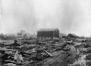
| Date: | |
|---|---|
| Description: | Large group of men posed standing in front of a sawmill. Three men are posed standing in a wagon pulled by a team of two horses wearing fly-nets. One man w... |

| Date: | 1914 |
|---|---|
| Description: | Map shows school houses, creameries, post offices, saw mills, grist mills, churches, cemeteries, town halls, stores, roads, state roads, and railroads. "Co... |

| Date: | 1953 |
|---|---|
| Description: | This mid 20th century map of Vilas County and northeastern Oneida County, Wisconsin, shows the township and range grid, sections, cities and villages, rail... |

| Date: | 1890 |
|---|---|
| Description: | Shows vacant state land, government land, townships, and selected farms, camps, saw mills, etc. in Vilas and Oneida Counties, and part of Iron County. "For... |

| Date: | 1892 |
|---|---|
| Description: | Map shows farms, schools, saw mills, townships, railroads, and roads. Counties are labelled and are outlined in yellow and pink. On the upper right and le... |

| Date: | 1857 |
|---|---|
| Description: | This map shows section corners, quarter section corners, foundry, steam saw mill, steam grist mill, planning mill, court house, baptist church, congregatio... |
If you didn't find the material you searched for, our Library Reference Staff can help.
Call our reference desk at 608-264-6535 or email us at: