 Filter: Categories of Wisconsin Historical Images
Filter: Subject of Sawmills
Filter: Subject of land
Filter: Year of 1900-1999
Filter: Categories of Wisconsin Historical Images
Filter: Subject of Sawmills
Filter: Subject of land
Filter: Year of 1900-1999

| Date: | 1905 |
|---|---|
| Description: | Elevated view of Soldiers' Grove with a bridge in the foreground. |

| Date: | 1913 |
|---|---|
| Description: | Bird's-eye map of Superior. "The New Steel Center." |

| Date: | 05 02 1964 |
|---|---|
| Description: | Sitting on the school lawn, students draw Highway 51, Marathon Mill, Rib mountain and the Wisconsin River. |

| Date: | 1904 |
|---|---|
| Description: | Logs floating down the Chippewa River in front of the "Big Mill". |

| Date: | 1906 |
|---|---|
| Description: | View from rocky shoreline of a lumber mill on the banks of the Chippewa River. Smoke is coming out from a smokestack. |

| Date: | 1907 |
|---|---|
| Description: | Elevated view from steep shoreline opposite a lumber mill on the far shore of the Chippewa River, with a bluff rising above it to the right. Boulders are o... |

| Date: | 1909 |
|---|---|
| Description: | A map of Langlade County, Wisconsin that shows townships and ranges, towns, cities and villages, wagon roads, churches, schools, sawmills, town halls, chee... |

| Date: | 1915 |
|---|---|
| Description: | This 1915 map of Lincoln County, Wisconsin, shows the township and range grid, towns, cities and villages, lakes and streams, residences, churches, school ... |

| Date: | 1914 |
|---|---|
| Description: | This 1914 map of Price County, Wisconsin, shows land for sale by the Good Land Company and Dewitt van Ostrand of Phillips. Also shown are the township and ... |

| Date: | 1900 |
|---|---|
| Description: | This 1900 map shows the township and range system, sections, cities and villages, railroads, roads, vacant land and land sold by the Wisconsin Central Rail... |

| Date: | 1909 |
|---|---|
| Description: | This 1909 map of Taylor County, Wisconsin, shows the township and range grid, towns, sections, cities and villages, settlers houses, schools, churches, saw... |

| Date: | 1908 |
|---|---|
| Description: | This 1908 map shows the town and range grid, sections, cities and villages, acreages, settlers, schools, wagon roads, railroads, saw mills, and lakes, stre... |
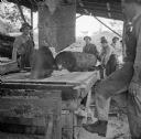
| Date: | 08 22 1943 |
|---|---|
| Description: | The sawmill for the engineers at the military camp on Kiriwina Island in the Solomon Sea, New Guinea (present day Papua New Guinea). The soldiers are just ... |
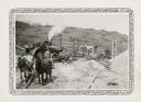
| Date: | 1932 |
|---|---|
| Description: | A steam tractor provides power for a portable sawmill owned by Jake Karken. The large sawblade is still as men pose for the photographer. There is a team o... |

| Date: | 1900 |
|---|---|
| Description: | This photostat of a manuscript map originally drawn in 1829 shows landownership, buildings, including Fort Howard and U.S. sawmill, swamps, public barns an... |

| Date: | 1900 |
|---|---|
| Description: | This photostat map shows private claim owners, natural meadows, roads, saw and grist mills, and Fort Howard. The upper right corner includes annotations an... |

| Date: | 07 13 1925 |
|---|---|
| Description: | View down slope towards a tractor powering a sawmill in a forest. There is a valley and hills in the background. |

| Date: | 07 13 1925 |
|---|---|
| Description: | View looking up slope towards a tractor-drawn sawmill. There is a tree-lined ridge in the background. |
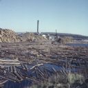
| Date: | 1957 |
|---|---|
| Description: | View from shoreline of logs floating in the water of Neopit Mill Pond. The sawmill is across the water, partially obscured by tall piles of logs. |

| Date: | 1901 |
|---|---|
| Description: | A Sanborn map of Tomahawk featuring the Bay Mill Company's lumber yard. |
If you didn't find the material you searched for, our Library Reference Staff can help.
Call our reference desk at 608-264-6535 or email us at: