 Filter: Categories of Wisconsin Historical Images
Filter: Subject of Sawmills
Filter: Subject of land
Filter: Subject of human settlements
Filter: Categories of Wisconsin Historical Images
Filter: Subject of Sawmills
Filter: Subject of land
Filter: Subject of human settlements

| Date: | 1881 |
|---|---|
| Description: | Bird's-eye map of Marinette, with insets. |

| Date: | 1905 |
|---|---|
| Description: | Elevated view of Soldiers' Grove with a bridge in the foreground. |

| Date: | 1886 |
|---|---|
| Description: | Bird's-eye view of Ashland, on the shores of Lake Superior, with insets of The Apostle Islands Chequamagon Bay & Ashland, and Distances from Ashland. |

| Date: | 1850 |
|---|---|
| Description: | Painting depicting Chippewa Falls and the first sawmill on the Chippewa River, built by Jean Brunet. The residence of H.S. Allen, one of the owners of the... |

| Date: | 1867 |
|---|---|
| Description: | Birds-eye drawing of Appleton, Outagamie Co., depicting street names and street layout, houses, the Fox River, the court house, jail, school houses, Lawren... |

| Date: | 1913 |
|---|---|
| Description: | Bird's-eye map of Superior. "The New Steel Center." |

| Date: | 1886 |
|---|---|
| Description: | Bird's-eye map of Washburn on Lake Superior. There is an inset of Washburn, Chequamagon and the Apostle Islands. |

| Date: | 05 02 1964 |
|---|---|
| Description: | Sitting on the school lawn, students draw Highway 51, Marathon Mill, Rib mountain and the Wisconsin River. |
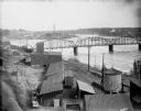
| Date: | |
|---|---|
| Description: | Elevated view of the riverfront, railroad tracks, and river, "as viewed from Joseph McGuire's." |

| Date: | 1904 |
|---|---|
| Description: | Logs floating down the Chippewa River in front of the "Big Mill". |

| Date: | |
|---|---|
| Description: | View from shoreline of lumber mill on the bank of the Chippewa River, with steam emitting from the smokestacks. A bridge over the river is in the right bac... |

| Date: | 1906 |
|---|---|
| Description: | View from rocky shoreline of a lumber mill on the banks of the Chippewa River. Smoke is coming out from a smokestack. |

| Date: | 1907 |
|---|---|
| Description: | Elevated view from steep shoreline opposite a lumber mill on the far shore of the Chippewa River, with a bluff rising above it to the right. Boulders are o... |

| Date: | |
|---|---|
| Description: | The Big Lumber Mill seen from across the Chippewa River under cloudy skies, with smoke coming out of several smokestacks |

| Date: | 1909 |
|---|---|
| Description: | A map of Langlade County, Wisconsin that shows townships and ranges, towns, cities and villages, wagon roads, churches, schools, sawmills, town halls, chee... |

| Date: | 1915 |
|---|---|
| Description: | This 1915 map of Lincoln County, Wisconsin, shows the township and range grid, towns, cities and villages, lakes and streams, residences, churches, school ... |

| Date: | 1896 |
|---|---|
| Description: | This 1896 map shows the township and range system, sections, cities and villages, railroads, vacant land and land sold by the Wisconsin Central Railroad, s... |

| Date: | 1898 |
|---|---|
| Description: | This 1898 map shows the township and range system, sections, cities and villages, railroads, vacant land, land sold by the Wisconsin Central Railroad, incl... |

| Date: | 1888 |
|---|---|
| Description: | This late 19th century map of Price County, Wisconsin, shows landownership and waterfront acreages, the township and range system, towns, cities and villag... |
If you didn't find the material you searched for, our Library Reference Staff can help.
Call our reference desk at 608-264-6535 or email us at:
