 Filter: Categories of Wisconsin Historical Images
Filter: Subject of Sawmills
Filter: Subject of land
Filter: Subject of bridges
Filter: Categories of Wisconsin Historical Images
Filter: Subject of Sawmills
Filter: Subject of land
Filter: Subject of bridges

| Date: | 1881 |
|---|---|
| Description: | Bird's-eye map of Marinette, with insets. |

| Date: | 1905 |
|---|---|
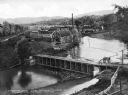
| Description: | Elevated view of Soldiers' Grove with a bridge in the foreground. |

| Date: | 1867 |
|---|---|
| Description: | Birds-eye drawing of Appleton, Outagamie Co., depicting street names and street layout, houses, the Fox River, the court house, jail, school houses, Lawren... |
| Date: | |
|---|---|
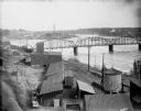
| Description: | Elevated view of the riverfront, railroad tracks, and river, "as viewed from Joseph McGuire's." |

| Date: | |
|---|---|
| Description: | Elevated view down hill toward old mill with a small bridge in the foreground, and another arched bridge over a steep-sided stream in City Park. Paths and ... |
| Date: | |
|---|---|
| Description: | Elevated view of the mill, dam, and railroad tracks, and forests surrounding the area. The lumber mill itself, with main building complex and smokestack is... |

| Date: | |
|---|---|
| Description: | View from shoreline of lumber mill on the bank of the Chippewa River, with steam emitting from the smokestacks. A bridge over the river is in the right bac... |

| Date: | 09 1891 |
|---|---|
| Description: | Sanborn map of Hurley, featuring the Village of Gile and the Montreal River Lumber Company. |

| Date: | 1898 |
|---|---|
| Description: | Sanborn map of Hurley featuring the Village of Gile. |
If you didn't find the material you searched for, our Library Reference Staff can help.
Call our reference desk at 608-264-6535 or email us at:
