 Filter: Categories of Wisconsin Historical Images
Filter: Subject of Sawmills
Filter: Subject of lakes
Filter: Subject of dwellings
Filter: Categories of Wisconsin Historical Images
Filter: Subject of Sawmills
Filter: Subject of lakes
Filter: Subject of dwellings
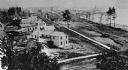
| Date: | 1885 |
|---|---|
| Description: | Elevated view of Shell Lake looking towards the sawmills. |

| Date: | 1871 |
|---|---|
| Description: | This map of Barron County, Wisconsin, shows the township and range grid, towns, sections, cities and villages, post offices, dwellings, schools, roads, swa... |

| Date: | 1909 |
|---|---|
| Description: | This map covers Iron and Price Counties and portions of Sawyer and Oneida Counties. The map shows vacant and sold Wis. Central Ry. land, settlers houses, s... |
If you didn't find the material you searched for, our Library Reference Staff can help.
Call our reference desk at 608-264-6535 or email us at: