Filter: Categories of Wisconsin Historical Images
Filter: Subject of Sawmills
Filter: Subject of human settlements
Filter: County of Bayfield
Filter: Categories of Wisconsin Historical Images
Filter: Subject of Sawmills
Filter: Subject of human settlements
Filter: County of Bayfield

| Date: | 1886 |
|---|---|
| Description: | Bird's-eye map of Washburn on Lake Superior. There is an inset of Washburn, Chequamagon and the Apostle Islands. |
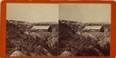
| Date: | 1875 |
|---|---|
| Description: | Stereograph view of Bayfield with a sawmill in the foreground. |

| Date: | 1900 |
|---|---|
| Description: | This 1900 map shows the township and range system, sections, cities and villages, railroads, roads, vacant land and land sold by the Wisconsin Central Rail... |
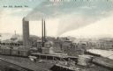
| Date: | |
|---|---|
| Description: | Elevated view of the saw mill. Lumber is stacked in front of several buildings and railroad tracks. Caption reads: "Saw Mill, Bayfield, Wis." |
If you didn't find the material you searched for, our Library Reference Staff can help.
Call our reference desk at 608-264-6535 or email us at: