 Filter: Categories of Wisconsin Historical Images
Filter: Subject of Sawmills
Filter: Subject of factories
Filter: Categories of Wisconsin Historical Images
Filter: Subject of Sawmills
Filter: Subject of factories
| Date: | 1867 |
|---|---|
| Description: | Mill dam and sash factory. "The Northwester Gateway. Excursion to Lake Superior, June 1867. Photographed and Published by J. Carbutt, 131 Lake St., Chicago... |

| Date: | 1867 |
|---|---|
| Description: | Birds-eye drawing of Appleton, Outagamie Co., depicting street names and street layout, houses, the Fox River, the court house, jail, school houses, Lawren... |

| Date: | 1913 |
|---|---|
| Description: | Bird's-eye map of Superior. "The New Steel Center." |
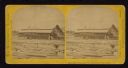
| Date: | |
|---|---|
| Description: | Elevated view of the riverfront, railroad tracks, and river, "as viewed from Joseph McGuire's." |

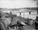
| Date: | 1910 |
|---|---|
| Description: | Chippewa Falls from the south side of the river below the falls. Includes the Sheely House Tavern, railway buildings, box cars, a train with five passenger... |

| Date: | 1902 |
|---|---|
| Description: | Two panoramic bird's-eye views of the Paine Lumber Company, including the general plant, sawmill, and lumber yards. Heading at the top says: Home of Wiscon... |
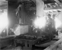
| Date: | 1900 |
|---|---|
| Description: | Two men using sawing machinery to make boards inside "Big Mill." |
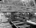
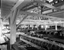
| Date: | 1900 |
|---|---|
| Description: | Interior view of large room filled with machinery inside a lumber mill. |
| Date: | |
|---|---|
| Description: | A room full of machinery in the "Big Lumber Mill." |

| Date: | 1904 |
|---|---|
| Description: | Logs floating down the Chippewa River in front of the "Big Mill". |

| Date: | |
|---|---|
| Description: | View from shoreline of lumber mill on the bank of the Chippewa River, with steam emitting from the smokestacks. A bridge over the river is in the right bac... |

| Date: | 1906 |
|---|---|
| Description: | View from rocky shoreline of a lumber mill on the banks of the Chippewa River. Smoke is coming out from a smokestack. |

| Date: | 1907 |
|---|---|
| Description: | Elevated view from steep shoreline opposite a lumber mill on the far shore of the Chippewa River, with a bluff rising above it to the right. Boulders are o... |

| Date: | |
|---|---|
| Description: | The Big Lumber Mill seen from across the Chippewa River under cloudy skies, with smoke coming out of several smokestacks |

| Date: | |
|---|---|
| Description: | East facing view from the Upper Bridge, featuring the Beloit water tower in the distance. |

| Date: | 1886 |
|---|---|
| Description: | This map has relief shown by hachures and includes a list of plats in order of date of record, laws which vacate plats, plats not shown as upon the county ... |

| Date: | 1888 |
|---|---|
| Description: | This map has relief shown by hachures and features inset maps of a plat of E.D. Clinton and Blackwell’s add’n to the City of La Crosse. Wards (1-10) shaded... |

| Date: | 1855 |
|---|---|
| Description: | This map is ink, pen, and watercolor on paper and shows plat of the town, local streets, lots by number, U.S. subdivisions in red lines, Mineral Point Rail... |

| Date: | 1923 |
|---|---|
| Description: | This blue line print map shows townships, landownership, roads, residences, churches, schools, town halls, saw mills, and cheese factories. Includes red ma... |
If you didn't find the material you searched for, our Library Reference Staff can help.
Call our reference desk at 608-264-6535 or email us at:
