 Filter: Categories of Wisconsin Historical Images
Filter: Subject of Sawmills
Filter: Subject of cities and towns
Filter: Subject of superior, lake
Filter: Categories of Wisconsin Historical Images
Filter: Subject of Sawmills
Filter: Subject of cities and towns
Filter: Subject of superior, lake

| Date: | 1886 |
|---|---|
| Description: | Bird's-eye view of Ashland, on the shores of Lake Superior, with insets of The Apostle Islands Chequamagon Bay & Ashland, and Distances from Ashland. |

| Date: | 1886 |
|---|---|
| Description: | Bird's-eye map of Washburn on Lake Superior. There is an inset of Washburn, Chequamagon and the Apostle Islands. |
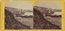
| Date: | 1875 |
|---|---|
| Description: | Stereograph view of Bayfield with a sawmill in the foreground. |

| Date: | 06 1923 |
|---|---|
| Description: | Sanborn map of Ashland, which includes Chequamegon Bay. |
If you didn't find the material you searched for, our Library Reference Staff can help.
Call our reference desk at 608-264-6535 or email us at: