 Filter: Categories of Wisconsin Historical Images
Filter: Subject of Sawmills
Filter: Subject of cities and towns
Filter: Subject of farms
Filter: Categories of Wisconsin Historical Images
Filter: Subject of Sawmills
Filter: Subject of cities and towns
Filter: Subject of farms
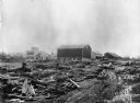
| Date: | 1890 |
|---|---|
| Description: | A view of Rudolph Herrling's sawmill and log yard in front of the Herling farm. |

| Date: | 1953 |
|---|---|
| Description: | This mid 20th century map of Vilas County and northeastern Oneida County, Wisconsin, shows the township and range grid, sections, cities and villages, rail... |

| Date: | 1890 |
|---|---|
| Description: | Shows vacant state land, government land, townships, and selected farms, camps, saw mills, etc. in Vilas and Oneida Counties, and part of Iron County. "For... |

| Date: | 1892 |
|---|---|
| Description: | Map shows farms, schools, saw mills, townships, railroads, and roads. Counties are labelled and are outlined in yellow and pink. On the upper right and le... |
If you didn't find the material you searched for, our Library Reference Staff can help.
Call our reference desk at 608-264-6535 or email us at: