 Filter: Categories of Wisconsin Historical Images
Filter: Subject of Sawmills
Filter: Subject of cities and towns
Filter: Subject of dwellings
Filter: Categories of Wisconsin Historical Images
Filter: Subject of Sawmills
Filter: Subject of cities and towns
Filter: Subject of dwellings

| Date: | 1881 |
|---|---|
| Description: | Bird's-eye map of Marinette, with insets. |

| Date: | 1905 |
|---|---|
| Description: | Elevated view of Soldiers' Grove with a bridge in the foreground. |

| Date: | 1886 |
|---|---|
| Description: | Bird's-eye view of Ashland, on the shores of Lake Superior, with insets of The Apostle Islands Chequamagon Bay & Ashland, and Distances from Ashland. |

| Date: | 1850 |
|---|---|
| Description: | Painting depicting Chippewa Falls and the first sawmill on the Chippewa River, built by Jean Brunet. The residence of H.S. Allen, one of the owners of the... |

| Date: | 1867 |
|---|---|
| Description: | Birds-eye drawing of Appleton, Outagamie Co., depicting street names and street layout, houses, the Fox River, the court house, jail, school houses, Lawren... |
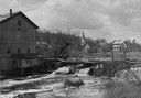
| Date: | 1948 |
|---|---|
| Description: | Elevated view from shoreline towards the opposite shoreline towards the Buettner mill on the left, and the river with a dam, on the right. In the backgroun... |
| Date: | 1885 |
|---|---|
| Description: | Elevated view of Shell Lake looking towards the sawmills. |

| Date: | |
|---|---|
| Description: | Elevated view of the lumber mill and surrounding area. In the foreground is a pond with logs floating in it. Along the shoreline are the buildings and comp... |
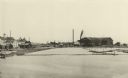
| Date: | 1887 |
|---|---|
| Description: | A view at the mouth of the Menominee River showing Ludington Wells and Van Schaick's mills. |
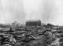
| Date: | 1890 |
|---|---|
| Description: | A view of Rudolph Herrling's sawmill and log yard in front of the Herling farm. |

| Date: | 1888 |
|---|---|
| Description: | This late 19th century map of Price County, Wisconsin, shows landownership and waterfront acreages, the township and range system, towns, cities and villag... |

| Date: | 1871 |
|---|---|
| Description: | This map of Barron County, Wisconsin, shows the township and range grid, towns, sections, cities and villages, post offices, dwellings, schools, roads, swa... |

| Date: | 1900 |
|---|---|
| Description: | Shows lands belonging to Wisconsin Timber and Land Co., towns, post offices, saw mills, creameries, camps, churches, schools, farm houses, town halls, rail... |

| Date: | 1857 |
|---|---|
| Description: | Relief shown by hachures. "Lith. of Ed. Mendel, Chicago." Shows townships and sections, rivers, roads, railroads, houses, flour mills, saw mills, furnaces... |
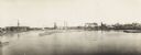
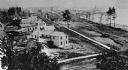
| Date: | 1900 |
|---|---|
| Description: | Semi-panoramic view of a river town showing extensive sawmill operations. |

| Date: | 1891 |
|---|---|
| Description: | This map shows vacant Southwick & Sellers lands, settlers' houses, Goodland Co. land, schools, churches, saw mills, roads, and railroads. A key in the uppe... |

| Date: | 1901 |
|---|---|
| Description: | A Sanborn map of Tomahawk featuring the Bay Mill Company's lumber yard. |

| Date: | 1875 |
|---|---|
| Description: | Elevated view of several buildings, with bridge and railroad tracks, and the Fox River. In the foreground on the right is the Commercial House, with three ... |
If you didn't find the material you searched for, our Library Reference Staff can help.
Call our reference desk at 608-264-6535 or email us at:

