 Filter: Categories of Wisconsin Historical Images
Filter: Subject of Sawmills
Filter: Subject of architecture
Filter: Subject of streams
Filter: Categories of Wisconsin Historical Images
Filter: Subject of Sawmills
Filter: Subject of architecture
Filter: Subject of streams

| Date: | |
|---|---|
| Description: | Elevated view down hill toward old mill with a small bridge in the foreground, and another arched bridge over a steep-sided stream in City Park. Paths and ... |
| Date: | |
|---|---|
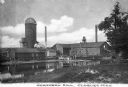
| Description: | View from shoreline across water toward the mill. To the right of the main building are two smaller structures, with a watertower and silo behind. Two smok... |

| Date: | 1915 |
|---|---|
| Description: | This 1915 map of Lincoln County, Wisconsin, shows the township and range grid, towns, cities and villages, lakes and streams, residences, churches, school ... |

| Date: | 1914 |
|---|---|
| Description: | This 1914 map of Price County, Wisconsin, shows land for sale by the Good Land Company and Dewitt van Ostrand of Phillips. Also shown are the township and ... |

| Date: | 1900 |
|---|---|
| Description: | This 1900 map shows the township and range system, sections, cities and villages, railroads, roads, vacant land and land sold by the Wisconsin Central Rail... |

| Date: | 1887 |
|---|---|
| Description: | This 1896 map shows the township and range system, sections, cities and villages, railroads, roads, vacant land and land sold by the Wisconsin Central Rail... |

| Date: | 1898 |
|---|---|
| Description: | This 1898 map shows the township and range system, sections, cities and villages, railroads, roads, vacant land and land sold by the Wisconsin Central Rail... |
If you didn't find the material you searched for, our Library Reference Staff can help.
Call our reference desk at 608-264-6535 or email us at: